PDF of the report.
This report is intended to demonstrate the consequences of blasting in known karst areas in Giles County, Virginia and Monroe County, West Virginia. Mountain Valley Pipeline did not fully implement the measures in its Karst Mitigation Plan or General Blasting Plan outlined in Section 4 of the Final Environmental Impact Statement (FEIS). There are serious issues that require further evaluation to avoid potential pipeline rupture and contamination of groundwater. This is a highly unstable area in karst terrain.
The corridor of the Mountain Valley Pipeline (MVP) passes through about 67 miles of significant karst area as it crosses the mountainous Valley and Ridge Province (the Appalachian Fold Belt) in Giles, Craig, Montgomery, and Roanoke Counties in Virginia and Monroe, Summers, and Greenbrier Counties in West Virginia. Karst is a landscape that is formed by the dissolving of bedrock. Severe karst can create hazards for structures that are built on or across it. The environment, both on the surface and in the subsurface, is more easily degraded in karst than in most other terrains. Moreover, the karst in this mountainous region is much different than that in other areas. Siting a pipeline through Appalachian karst poses significantly greater hazards than in karst areas where the terrain has lower topographic relief.
Karst is a critical factor in siting and management of a high-pressure gas pipeline such as the MVP. However, other potential hazards such as land instability, problem soils of shrink-swell clay mineralogy (soil series CARBO) on steep slopes with fluctuating water tables, and potential seismicity are highly significant in this region. When two or more of these hazards act together, the resulting environmental threat from the pipeline is compounded and exacerbated.
This report concludes that karst and associated hazards constitute a serious threat to the proposed pipeline and groundwater contamination. Impacts of these threats are beginning to appear along the corridor as shown in the photos of sinkholes forming in the right-of-way in Giles County. Since Spring 2019, nine sinkholes have appeared in a span of 500 feet on top of a ridge line.
Giles County
In Giles County, the property owner and Mountain Valley Watch volunteers inspected areas and took photos of sinkholes forming in the right-of-way on three occasions: May 14, 2019; June 24, 2019; and April 15, 2020. Photos included in this report show the locations of visible sinkholes forming and continuing subsidence in the MVP right-of-way. In a 12-month interval, nine sinkholes appeared with significant subsidence exposing cavities that extend beyond the extent of visual inspection.
In July 2018, an underground cavity or small cave was opened as a result of rock blasting in the MVP right-of-way near the Craig/Giles County line, between mile markers 216 and 216.5. The blasting was heard by local residents four miles away. It is clear that an underground cavity system exists in this area.


Exposed rock shown in the photos is limestone of high calcium carbonate content, and effervesces violently with contact to 10% Hydrochloric acid.
The cavities exposed by blasting are approximately one mile from the entrance to the Canoe Cave system. The route of the Mountain Valley Pipeline crosses a portion of Canoe Cave, located along the northwestern flank of Sinking Creek Mountain in Giles County. Canoe Cave contains water, is inhabited by significant biota, is designated as a cave conservation site, and is near the surface with little overlying bedrock. At approximately 3,000 feet in length, Canoe Cave was designed as a significant cave by the VA Cave Board and the VA Speleological Survey (Kastning, 2016), and is surrounded by the Canoe Cave Conservation Site designated by the VADCR. A portion of the cave was mapped in 1943, surveyed in February 1982 by Dr. Gary Nussbaum of Radford University, biologically inventoried by the VADCR in November 2015, and is currently being resurveyed by the VA Speleological Survey. Inspections suggest that the cave is located close to the ground surface. Historical mapping of Canoe Cave indicated underground stream flow coming from the upland mountain ridge to the northeast. The pipeline is about 900 feet away from the nearest entrance to Canoe Cave.

The route of the Mountain Valley Pipeline passes over the Canoe Cave system. Sinkholes that take allogenic recharge (swallets) and a spring directly downhill from the cave (a likely resurgence of water from the cave) are indicated in Figure 2. The area outlined in light blue is a designated cave conservation site.
Springs in the colluvium above the cave are reportedly used as a source of water supplies. Water from this zone enters the soluble rock in the vicinity of Canoe Cave and the water encountered in the cave is from swallets east of the cave entrance that takes allogeneic water from above. In places, Canoe Cave is very near the surface, with little overlying bedrock.
Canoe Cave, the colluvial material, swallet, and spring together constitute a hydrologic groundwater system. There is a swallet directly upgrade of the location of the sinkholes in the right-of-way. This swallet drains a large area at the toe of Sinking Creek Mountain. Surface runoff flows into the swallet which then flows underground below the ridgeline on which blasting for the MVP occurred. Blasting in this area of karst topography has changed groundwater flow patterns, and may affect the yield in nearby springs and wells.
Figure 3 shows the location of Canoe Cave in relation to the blasted area with sinkholes and caverns formed in the MVP right-of-way between mile markers 216.1 and 216.5. The blue dots in Figure 3 show the locations of drone and ground photos taken in the field on June 24, 2019. The orange dots in Figure 3 show the locations of photos of new sinkholes forming in the MVP right-of-way on April 19, 2020.

The forming of sinkholes in the MVP right-of-way is an indicator of the presence of Canoe Cave drainage network. The strongest surficial evidence for the presence of an efficient and well-integrated subsurface drainage network is where sinkholes form at discrete points of recharge. Sinkholes form in response to surficial waters draining through the ground via the easiest pathway toward the local groundwater level.
Field Observations and Photos
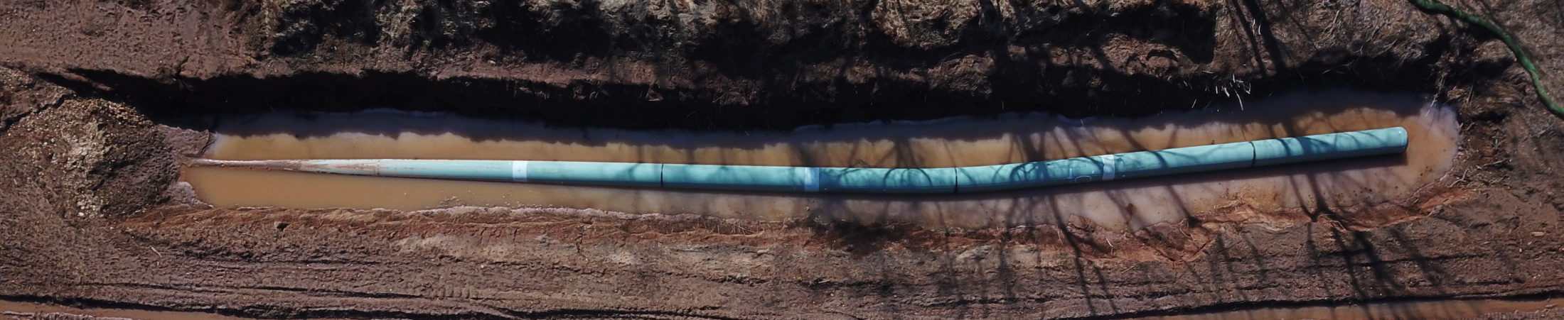
Field photos show areas of subsidence and sinkholes beginning to form within right-of-way after rock blasting between mile markers 216.1 and 216.4. Several areas of significant subsidence are encircled in silt fences. Blasting of rock in July 2018 during pipeline construction exposed cavities that were not visible before construction began. During site visits, drilled blast holes were found and measured for depth. Several blast holes measured between eight to eleven feet in depth. During observation of measurements, the measuring device could be heard passing through underground cavities and hitting underground water at the bottom of blast holes.


In June 2019, a month after images in Figures 5 and 6 were taken, photos taken during site visit show expanding areas of subsidence in Figures 7 and 8. These photos were taken at the same locations as Figures 5 and 6.


Inspection of the site in April 2020 shows new areas of subsidence and recently formed sinkholes in the MVP right-of-way.


Due to steep slopes combined with CARBO shrink-swell clay soil series at this location, soil material above and over the cave will be prone to significant mass movement. This location will be highly problematic if:
- a severe rainfall event occur and enable downslope soil movement;
- a sizable earthquake occur (the area is in close proximity to the Giles County Seismic Zone); or
- slow and persistent downslope soil movement (soil creep) deform the pipe.
Any of these impacts are sufficient to cause pipeline rupture.
Monroe County, WV
Monroe County, West Virginia is home to extensive areas of karst and is well-known for a large number of caves. The MVP segment between mile markers 181 and 195 in Monroe County poses significant concerns where it passes through numerous interacting karst features, including springs providing allogenic recharge, sinkholes, caves, and a sinking stream. Within this segment, the corridor ascends the northern flank of Peters Mountain where it encounters steep slopes, karst geology, and unstable soils in an area of enhanced seismic risk.
In October 2018, MVP began blasting and trenching through limestone and karst areas on a farm north of Peters Mountain in Monroe County. Blasting was felt by local residents over one mile away. The property owner and neighbors have reported that their water supply is polluted from sediment flowing into well systems. They have to transport water to their homes for domestic use. The following are pictures of blasted limestone rock from the pipeline trench.


Twelve miles south of the area shown in the above photos, numerous karst features occur between Little Mountain and Peters Mountain. In this section, Rich Creek Cave was formed in the Ordovician carbonates south of Lindside. The cave is an incredible spring that often spouts water through its small entrance on high-flow days. Rich Creek Cave is the source of an important headwaters spring for Rich Creek, a back-up resource for the Red Sulphur Water District.


The corridor through Monroe County has significant areas of karst topography with known sinkholes and caves that present “pipeline constructability issues”.
During the past five years, Indian Creek Watershed Association (ICWA) has filed comments on the FERC docket which have pointed out hazards on the section between Little Mountain and Peters Mountain to the southwest of the town of Lindside (approximate mileposts 194-195). ICWA concerns in this area include:
- Emergence of sizable sinkholes on property adjacent to the MVP indicating active subsidence in the area.
- A “sinking stream” that will be crossed by the pipeline at Wilson Mill Road. The stream feature also runs close to or under a proposed MVP workspace
- Documented underwater passageways flowing underneath the pipeline from Wolf Cave to the Rich Creek Cave/Spring, as noted below.
- Proximity of the pipeline corridor to Rich Creek Cave. Rich Creek Cave is a karst resurgence that is a primary source of water for the Rich Creek Trout Hatchery. Blasting or trenching in this area could disrupt underground geologic structure and water flow patterns. It is not known at this point whether the cave runs underneath the pipeline, but recent mapping shows that it trends in that direction.
Dye tracing studies initiated by WVDEP in 2018 confirm that a groundwater connection exists passing below the MVP corridor as shown in Figures 23A and 23B.


On September 20th, 2017, members of the West Virginia Caver organization (in The West Virginia Caver, February 2018, Volume 36, number 1, Rich Creek Cave article by George Dasher) started surveying the previously unmapped cave, venturing about 1,600 feet before coming to a sump. In November 2017, an experienced cave diving team returned to continue mapping the underwater part of the cave.
- The cave was determined to be approximately 1,800 feet long, heading in a south-southeast in the direction of the pipeline corridor.
- The front aspect of the cave is a mixture of running stream passage, punctuated by large breakdown rooms.
- The underwater passage was mapped about 189 feet before the divers had to stop their exploration. Additional underwater passages were indicated.
- Figures 24 to 26 show several cave features found during the survey.


These karst features are all part of a limestone formation that extends along the base of Peters Mountain for almost its entire length in Monroe County. Several external forces at this location increase the potential for significant impacts including:
- active sinkhole formation in close proximity to the pipeline route,
- severe rainfall events could enable downslope soil movement,
- a sizable earthquake could deform the pipe, or
- slow and persistent downslope soil movement (creep) could deform the pipe.
It is unknown what impact a pipeline rupture or contamination event might have on critical water sources, because the extent and possible interconnections of underground aquifers along Peters Mountain were not adequately studied or mapped.
No blasting has yet taken place above the cave, and construction of this section of the pipeline has been suspended pending the permit to cross the Appalachian Trail and the Jefferson National Forest. However, the same issues exist in Monroe County that have occurred in Giles County. Both areas have extensive underground cave systems in karst geology that are sensitive to disruption by heavy construction. In Giles County, there is strong evidence of destruction of a cave system due to blasting. The same situation is waiting to happen in Monroe County.
Karst Mitigation Plan and Blasting Plan
Blasting in the vicinity of karst systems poses significant threats to both residential water sources and to the structural integrity of a large, high-pressure pipeline. Blasting may affect localized depth to groundwater, recharge characteristics and water quality. The main problems associated with construction in karst terrain are:
- difficulties in excavation and grading the ground;
- collapse of the roof over subsurface voids, subsidence of cover soil over sinkholes; and
- difficulties in stabilizing structures over an irregular or pinnacled rockhead.
As shown in the included photos, the roof of the cave in Giles County was removed by blasting and is collapsing in the right-of-way over subsurface voids. Blasting for the pipeline trench exposed an underground drainage network that flows into Canoe Cave. Flow stone and stalactites were exposed by blasting as shown in Figures 1A – 1C. It is clear that an underground cavity exists in this area. Sinkholes are forming directly over the pipeline. The extent of the underground caverns, potential impacts to underground aquifers, and potential structural impacts to the pipeline requires immediate evaluation.
In the case of the Mountain Valley Pipeline, buffer zones were not delineated in areas of karst where there are known high densities of sinkholes, extensive mapped caves, long groundwater flow paths documented by dye-tracing, and significant allogenic recharge. Buffer zones would have defined areas that should be protected from pipeline development, especially where there are potential impacts to sensitive features within karst.
Derangement of drainage networks brought on by pipeline construction can result in severe imbalances in water budgets, and thereby critical lowering of water levels in wells or reduction of discharge through flow systems, including caves. Alteration and derangement of flow paths can readily impact existing water supplies and can change the hydrologic character of caves, severely affecting the growth of speleothems or disrupting delicate biological ecosystems. Unfortunately, once pipelines are built, these effects may not be easily detected from the surface and it may be too late to correct any harm that may have been done. Canoe Cave in Giles County is among those of particular concern.
Recently, evidence of pipe movement was verified in Spread B due to overburden sliding downhill. On April 8, 2020, Cardno Lead Environmental Inspector for the MVP notified the Compliance Monitor that the installed pipe shifted due to the movement of slips in at least three locations south of Brush Run Road near mile marker 56.7. Mountain Valley is still determining a course of action to correct the movement.
A similar situation is developing in the Cave Canoe vicinity of Spread G. Giles County is blanketed with slip-swell soils, far more than any of the other counties along the route. Due to the combination of steep slopes and slip soils, slope stability is a critical issue. This area is highly unstable after frequent, severe rainfall events occur that can trigger downslope soil movement which causes the pipeline to deform. Subsurface voids underneath the pipeline are a threat to structural integrity. Soil movement combined with subsurface voids under the pipeline significantly increases the risk of pipeline deformation or rupture.
Mountain Valley developed a Karst Mitigation Plan in Section 4.1 of the FEIS (Section 2.4.2.17 Karst Terrain – page 2-50 FEIS). The Karst Mitigation Plan gives details for inspections that take place during construction, procedures for unanticipated karst discoveries, mitigation options for karst features encountered during construction, and procedures for coordination with state agencies. Key elements of the Karst Mitigation Plan include:
- deployment of a karst specialist to evaluate areas of potential karst prior to and during construction;
- completion of inspections to document any subsidence, rock collapse, sediment filling, or other morphologies at identified karst features on a weekly basis;
- coordination with the appropriate state agencies for larger previously unidentified karst features or caves identified during construction; and
- monitoring during and post-construction for any subsidence or karst hazards.
If a significant, previously unknown karst feature is discovered during construction, the Karst Mitigation Plan indicates Mountain Valley would attempt to avoid the feature through route changes before attempting to stabilize and mitigate any discovered features.
If a karst feature is identified, Mountain Valley committed to conducting a weekly Level 1 inspection and document soil subsidence, rock collapse, sediment filling, swallets, springs, seeps, caves, voids, and morphology. If any changes are identified during the weekly Level 1 inspection, Mountain Valley would conduct a more in-depth Level 2 inspection. A Level 2 inspection would include visual assessment, geophysical survey, track drill probes, infiltration, or dye tracing. If a feature is found to have a direct connection to a subterranean environment or groundwater flow system, Mountain Valley would work with the karst specialist and appropriate state agencies to develop mitigation measures for the karst features. If larger or more continuous (coalescing) karst features or a cave is identified during construction, the karst inspector would coordinate with the appropriate state agencies regarding mitigation and/or avoidance of the discovered feature.
Mountain Valley also developed procedures that it would follow should blasting be required to construct the MVP in karst terrain. These procedures, contained in Mountain Valley’s General Blasting Plan (Mountain Valley Project and Equitrans Expansion Project, Final Environmental Impact Statement, Page 4-60), include:
- exploring all other reasonable potential means of excavations;
- employing karst specialists during blasting activities in karst areas;
- obtaining federal, state, and local authority approval prior to blasting;
- inspecting excavated areas for voids and remediating voids (karst features) prior to blasting; and
- using low force charges designed to only affect the rock to be removed.
Blasting would only be used in areas of shallow bedrock after all other means of trench excavation have been considered. In addition, Mountain Valley would not conduct blasting in karst areas without a karst specialist and approval of a karst blasting plan by federal, state, and local agencies.
Despite numerous site visits and inspections of this area in 2019 by Mountain Valley’s karst specialists, inspection personnel ignored obvious signs of expanding sinkholes in the right-of-way. In a letter to FERC in August 2019, an MVP attorney stated that “Based on this inspection and the prior inspections, the most likely cause of these small closed depressions is soil settling and raveling into the voids between the fragmented rocks…. While the participants in the July 2019 inspection could not categorically exclude raveling of material into any pre-existing karst voids and conduits, there is no direct evidence that such features are present in this area, and the presence of such features is not necessary to explain the observed subsidence. If pre-existing karst voids and conduits were present at this location, more significant and continued subsidence would have been expected” (August 7, 2019, Letter to Kimberly D. Bose, Secretary, Federal Energy Regulatory Commission, Re: Mountain Valley Pipeline, LLC, Docket No. CP16-10-000, Compliance with Karst Mitigation Plan).
This is a poor assessment of the existing geology of this area. Since 2019, four additional sinkholes have appeared in a line with the previously identified sinkholes. The depth of the sinkholes have increased. A new sinkhole shown in Figure 10 to 14 is not measurable by conventional measuring devices due to the depths. This is a known karst area. The ridgeline is like swiss cheese with numerous subterranean cavities. There is extensive evidence of karst features in this area which jeopardizes the structural integrity of the MVP.
Procedures outlined in the General Blasting Plan were not followed as demonstrated by drilling of blast holes exceeding eight feet in depth. Heavy charges were used to remove rock and overburden in the pipeline right-of-way. Ten to twenty feet of overburden and rock were removed from the ridge top. Blasted rock from the roof of underground passages is seen strewn along the edge of the right-of-way. Blasting was heard four miles away.
Summary and Conclusions
Giles County and Monroe County have highly unstable conditions for construction of a pipeline due to a combination of karst geology, unstable soils, steep slopes, and a seismic zone. Canoe Cave has already been disrupted by blasting as demonstrated by numerous photos and site visits by local residents. Rich Creek Cave is in a similar situation as Canoe Cave, but construction has not started yet in this area.
We strongly urge Federal and State agencies to take immediate action to review the conditions and permits for construction in Giles and Monroe Counties. The area is too unstable to continue construction. Site conditions combined with rainfall events, seismicity, and soil creep are sufficient to cause pipeline rupture.