PDF of the report.
August 10, 2018 (REVISED – August 19, 2018)
The following report was created by Mountain Valley Watch, a collaboration of public, private, and non-profit interests, and documents repeated failures of Mountain Valley Pipeline, LLC (Mountain Valley) and its contractors to protect water quality while constructing the Mountain Valley Pipeline (MVP). This information is relevant to the Board’s consideration of the sufficiency of NWP 12 because it (1) documents harm to streams directly caused by crossings authorized by NWP 12 despite that permit’s conditions and (2) documents harm to streams from sedimentation from upland areas. The information contained in this report further demonstrates that the Board must exercise its authority to require individual review of all waters crossed by the Mountain Valley Pipeline to determine if additional safeguards are necessary to protect Virginia water quality.
The incidents documented in this report establish that the plans and BMPs currently in use are inadequate to protect Virginia’s streams from the threats posed by construction of the pipeline. The Board and DEQ should take swift action to neutralize these threats. Many of these problems stem directly from the Department of Environmental Quality’s approval of a variance allowing Mountain Valley to maintain 5,000 feet of open trench. This length of open trench requires a minimum of 15 acres of disturbed area remain exposed to rainfall events while the trench is open. Long open trench lengths increases the amount of right of way subject to erosion.
Introduction
Virginians, particularly in the southwestern part of the state, have the good fortune of benefitting from its natural environment, aquatic diversity and the most pristine mountain water in the world.
“Regional fish diversity in the Southeast is the highest in North America north of Mexico (Warren et al. 1997), and an estimated 91% of all the freshwater mussel species that occur in the United States are found in the Southeast (Neves et al. 1997) (Neary and Michael. 2009)” (VDF, 2011: 7-9). The Department of Environmental Quality (DEQ) is statutorily responsible for maintaining that quality.
Failure of DEQ’s Nationwide Permit 12 Decision and Certification of the MVP
This work builds on letter by Dr. Jacob Hileman to the Virginia State Water Control Board (WCB), dated May 30, 2018, detailing objections to DEQ’s determination of the validity of the U.S. Army Corps of Engineers’ Nationwide Permit 12 as applied to Mountain Valley Pipeline. It details violations of permit conditions and failure to employ Best Management Practices (BMP) during early pre-construction and construction activities.
The first part of this report builds on Hileman’s work, reporting an ever increasing number of violations to date. Persistent failures (often repeated and in the same locations) raise the question of whether they are solely due to the ineptitude and lack of professionalism of the contractor, Precision Pipeline (which has a record to this effect), or if there is a deeper cause: the limits of BMPs in the mountainous and karst terrain selected for the pipeline route. For that we turn to the academic literature on the efficacy of BMPs and the conditions that affect it. DEQ appears not to appreciate the limits of BMPs and the fact that the construction of a large gas pipeline here poses an eminent, profound threat to Virginia waters. Finally we critique the myopic focus of the 30-day public comment period to pipeline crossing of surface water bodies while ignoring the potentially even greater threat posed by construction along ridges for upland tributaries.
Executive Summary
The data demonstrates that:
- Precision Pipeline frequently failed to employ Best Management Practices and properly install required erosion control devices and maintain them. The direct result is the serious impairment of Virginia waters.
- The extent and repetition of these failures (often in the same location), consistent with research in referenced journals, indicates the limitations of BMPs in mountainous terrain. BMPs are not infallible, nor are they intended to be so; they are designed to minimize adverse impacts. Rain events, well within the standard of “normal,” on steep slopes of upland watersheds overwhelm BMPs. This is documented in scientific reports in refereed journals.
- The processes by which DEQ decided the Nationwide Permit 12 and conducted the 30 day public comment period were fundamentally flawed, contributing to an unsubstantiated opinion that MVP construction would not significantly impair Virginia waters. This report demonstrates significant sediment loading into streams.
- It is imperative that DEQ and the SWCB revisit their decisions to approve the Section 401 Certification and Nationwide 12 permit for the Mountain Valley Pipeline.
- There is a reasonable likelihood, based in on the facts on the ground, that continued construction will continue to significantly adversely impact Virginia water for years to come.
Storm Water Runoff Impacts
Our analysis begins with vulnerability of Virginia waters to pipeline construction during normal rain events in upland watersheds. An understanding of the impacts of stormwater runoff on erosion and sedimentation is key to understanding the threat to Virginia waters from building a large diameter gas pipeline through the karst laden Ridge-and-Valley Appalachian Region.
The top three contributors (in terms of frequency and magnitude of impact) to runoff resulting from precipitation (called “nonpoint source pollution”) in rural and forested areas are: road construction, lumbering (including skidding), and site preparation (VDF, 2011: 1). Construction of a 42-inch pipeline is of an order of magnitude greater because it typically combines all three activities, is far more disruptive and the limits of disturbance (LOD) is much greater than any forest road.
Best Management Practices1 are designed to minimize runoff and they typically do well. However, BMPs are intended to be both practical and affordable, not infallible. Engineering limitations are inherent in technology based standards, subject to the laws of physics.
This has direct policy implications. The proper installation and maintenance of BMPs alone do not provide a basis for concluding there is not a reasonable threat to state waters from large pipeline projects. The efficacy of BMPs is conditional, dependent on slope, soil type, the area affected and intensity of activity. (VDF: 2011: 2). One of the most important factors, apparently not fully considered by DEQ, is the effect of normal rains on the upland ephemeral area of mountain watersheds and its implications for downstream impacts.
Watersheds
Essential to understanding the challenge to BMPs in the Valley and Ridge Province is the nature of watersheds in mountainous regions. Watersheds are the first substantive topic of Virginia’s Forestry Best Management Practices for Water Quality Technical Manual, 2011 (VDF, 2011) – for a reason. “A watershed is a land area where precipitation collects and funnels to an outlet – usually a stream. Figure 1, from 2011 Forestry Best Management Practices for Water Quality, shows perennial streams, intermittent streams and wetland areas illustrated over a watershed.
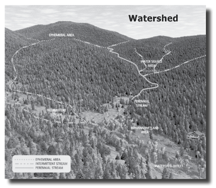
A comparison widely used is that of the roof on your home. Rain falls on the roof and moves by gravity toward the gutters, collecting debris and materials as it flows. The water eventually reaches the downspouts where it concentrates, picking up speed and additional debris. Different land uses affect watersheds differently. The effect of storms is dependent on slope, soil type and overall land use. For example, precipitation moves more slowly through a forested watershed than through an urban watershed because organic forest soils absorb the rainfall’s energy more efficiently than rooftops and pavement in urban settings. Land-disturbing activities, such as road construction, timber skidding and site preparation [e.g. clear cutting that destroy forest canopy and grubbing], can greatly affect the movement of water and associated debris, including sediment, to a stream. One must be careful when conducting silvicultural operations so soil movement is minimized. Of particular importance are the intermittent streams [emphasis added] that, despite not having water in them most of the year, can contribute to downstream water quality. The use of heavy equipment during timber harvesting can lead to altered and compacted soil causing downstream water quality problems if forest operators do not properly use BMPs.” (VDF, 2011: 7-9)
An understanding of watersheds should raise serious questions about
- the Virginia DEQ/WCB certification of NWP 12 based on its determination “that there is a reasonable assurance that the activities permitted under the Corps’ NWP program…will be conducted in a manner which will not violate applicable water quality standards”
- its limiting the public comment period to “specific, wetland or stream crossing(s).”
A focus on traversing specific water bodies is myopic. An equal or greater danger to water quality lies above, on highland ridges, where much of the pipeline Limits of Disturbance (LOD) has been located, where there are steep slopes and proximate, often dry gullies that fill during storm events or following multi-day rain events which saturate mountain soils. Impacted intermittent streams may not be directly touched by the LOD. When storm water is channeled from the LOD, without hardening the work site to slow down and dispersed flow to proximate upland tributaries, there is a documented indirect threat to the quality of the downstream river continuum.
1 Definitions of BMP:
Dictionary of Forestry (Helms 1998): “a practice or usually a combination of practices that are determined by a state or a designated planning agency to be the most effective and practicable means (including technological, economical, and institutional considerations) of controlling point and nonpoint source pollutants at levels compatible with environmental quality goals.”
Businessdictionary.com: Methods or techniques found to be the most effective and practical means in achieving an objective (such as preventing or minimizing pollution) while making the optimum use of the firm’s resources.
Part I: Mountain Valley Watch
Mountain Valley Watch (MVW) is a collaboration of public, private, and non-profit interests working to monitor construction of the Mountain Valley Pipeline (MVP) for compliance with the applicable Erosion & Sediment Control (ESC) and Stormwater Management (SWM) regulations. MVW was established to provide support to the limited resources of the regulatory agencies having oversight of this extensive project and also to promote public interest in citizen science. MVW volunteers receive regular training by ESC/SWM professionals in order to provide this valuable public service.
Monitoring began with tree-cutting and will continue until reclamation is achieved. Details and supporting photo documentation of alleged violations and concerns are submitted to MVW by our volunteers. Formal reports are then submitted by MVW to the Virginia Department of Environmental Quality (DEQ) via an online pollution reporting form and emails to DEQ staff. Recorded footage from drone and piloted aircraft supplements ground monitoring efforts during construction. Transparency builds trust; therefore all documentation is publicly accessible.
The patterns we have observed and documented in the field include non-compliance with the approved plan, improperly installed BMPs, consistently overwhelmed BMPs, lack of BMP maintenance, and the consequential impacts to properties and waterways.
This report gives an overall summary of the most significant volunteer observations and alleged violations reported to DEQ for evaluation and follow-up during construction from May 2018 to August 7, 2018. Some of the major problems reported include:
- Water bars/right-of-way diversions constructed across temporary and permanent right of way (ROW) are creating discharge points of concentrated runoff. Concentrated runoff is not returned to sheet flow, as required by the regulations, and is flowing down the slopes creating gullies and into existing gullies with high sediment concentrations.
- BMPs installed perpendicular to the contour are creating gullies along the perimeter of construction ROW.
- No evidence of stable conveyance channels or level spreaders to convey runoff downslope in a non-erosive manner.
- Drainage areas flowing to BMPs exceed performance limits and capacities of BMPs to effectively remove sediment.
- Lack of proper BMP maintenance and repairs.
These problems and others have been reported repeatedly for multiple areas, even after sites were “released” for work from the voluntary work stoppage MVP undertook with DEQ.
This strikes at the core of the argument that this project can not be constructed through steep, mountainous, rocky terrain without causing severe water quality damages to downstream properties and communities. As source water communities along the eastern continental divide, it is critical that we consider the financial and environmental impacts to downstream communities.
Compounding Geohazards
Through Virginia, the MVP will traverse some of the steepest terrain in the state. As shown in the Final EIS, 46% of the MVP project slopes are high erosion hazards and 22% are moderate erosion hazards. (D’Ardenne, D. 2018) Table 1 lists the ROW distance of slopes in Virginia. Soils on the highest ridges are mostly stony, gravely or sandy. Lower limestone ridges, where MVP is most active, are clayey, erodible, plastic and slip-prone. Both surface provides an unstable building environment for disruptive activities, in particular heavy machinery, and increase the likelihood of erosion and stormwater runoff. This issue was illustrated very recently with the explosion of the Leach Xpress Pipeline in Moundsville, WV, which was reportedly caused by a landslide. Add karst topography with shrink/swell clay soils, and the local environment becomes much more complex. There are a number of threats, including landslides, which are of considerable concern. Diversion bars cause water to form new flow paths off the ROW. Additionally, the ROW is now an exposed surface so the concentration of water increases greatly with no canopy to protect the ground from raindrop impact.
| Max Slope (%) | Distance (miles) |
| 30-39.9 | 8.07 |
| 40-49.9 | 6.55 |
| 50-59.9 | 3.48 |
| 60-69.9 | 1.34 |
| 70-79.9 | 2.02 |
| 80-89.9 | 0.17 |
Table 1: Steep slopes in Virginia
Total Distance = 21.63 miles
Total ROW Area of slopes > 30% in VA = 327.73 acresDoes not factor additional work areas or access roads, this is only area of slopes >30% and within 125′ construction ROW
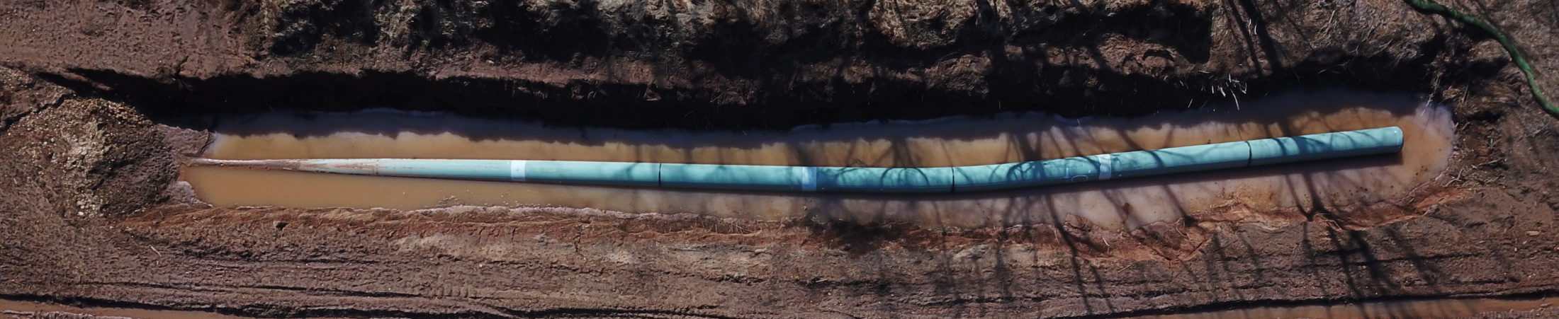
The map in Figure 2 gives an overview of the construction corridor over Peters Mountain. It is apparent that not all stream or flow channels are taken into account. The blue stars show MVP identified stream crossings, however a number of flow channels (marked green) were not identified as “streams”. Omitting these surface and underground water channels gives an incomplete analysis of upland water channel flow and their significant contribution to the flow of water coming off the ridges into karst terrain. Observations show that the 125 foot wide construction corridor with water diversion bars produces erosion gullies in the center and along the perimeter of the construction corridor. These erosion gullies typically flow to the lowest point at the toe of a steep slope where the BMP fails due to lack of capacity to control the flow of runoff and sediment. The diversion bars are designed in the construction details to include a small stone outlet structure with gravel filter and silt fence. Small retention areas constructed in clay rich soils as outlet structures along the entire Virginia route are not draining. The structures fill up after the first rain event and overflow with each successive rain event.
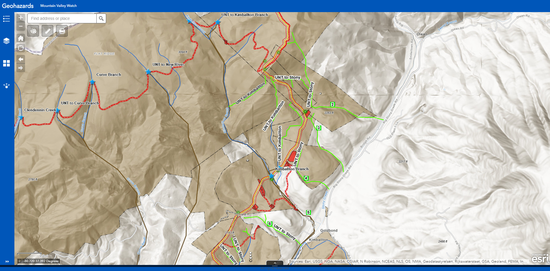
Click for access to interactive map.
Volunteer Observations and Submissions
As of August 7, 2018, Mountain Valley watch has received 277 volunteer submissions from which we have referred 58 reported violations to DEQ. A snapshot of the data dashboard, figure 3, displays each volunteer observation and map location. The dashboard includes two different forms created in the reporting application Survey123, a visual assessment on the left and an erosion control survey on the right. You can explore the points by clicking on them to view additional information. The aforementioned figures show the survey form section layouts. The visual assessment survey is based on Trout Unlimited’s monitoring program; the erosion control survey is based on the Virginia Sierra Club’s construction monitoring checklist.
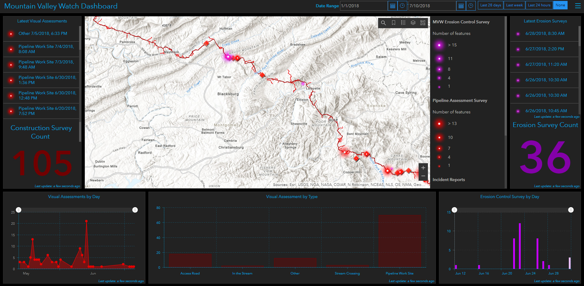
Click for access to interactive dashboard.
Case Studies
Below are 10 case studies, built around collages of photo evidence, of the worst, most persistent ESC/SWM failures. When possible location maps are included in the case study showing the construction ROW in red, pipe centerline in yellow, and a yellow star marking observer location.
Case Study 1: Hodges Property – Craig County Virginia
Observations from landowner Steven Hodges, Professor of Managed Ecosystems & Soil Science
GPS Location 37.32464 -80.43124 from Google Earth
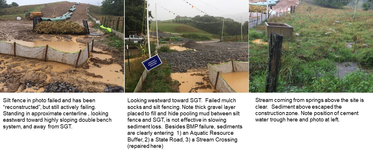
Rain fell on Aug 1 (0.22”), Aug 2 (0.16”) and Aug 3 (1.51”), Aug 4 (1.24”) , and Aug 05 (0.01”) at this site, for a total of 3.14,” with significant rains ending essentially before 6 am on Thursday, Aug 04. In no case did these daily events come close to exceeding even 1-year and 10-year 24-hour design storm events (2.14” and 3.82” respectively) for the NOAA Newport reporting station. NOAA PDS-based point precipitation frequency estimate are found at: (https://hdsc.nws.noaa.gov/hdsc/pfds/pfds_printpage.html?st=va&sta=44-6046&data=depth&units=english&series=pds). The total for the 5-day storm event lies slightly above the 1-year, 4-day (2.87”) estimate, well below the 1-year, 7-day (3.35”) estimate, and far, far below the 10-year, 4-day design storm estimate of 5.00”. The constructed BMPs should have no problem in preventing sediment losses during this 4 to 5-day event.
I informed MVP crew members that I am an environmental soil scientist familiar with erosion predictions and control structures. This segment of the pipeline has several sensitive areas: an aquatic resource buffer, a stream crossing, karst landscapes including numerous sinkholes, and the centerline passes through a sinkhole with an open throat and active signs of subsidence. The soils are clayey, slip-prone, and occur under highly sloping conditions. The MVP contracted engineer who marked the center-line route declared this site as “unconstructable?”
MVP crews have spent an incredible amount of time, energy, structural design and implementation on this site. I was informed that some of these structures were required by DEQ. This should be THE show-piece for DEQ-mandated and MVP-implemented effectiveness in erosion and sediment control.
How is MVP performing and how well is DEQ protecting sensitive karst and surface water resources at this site?
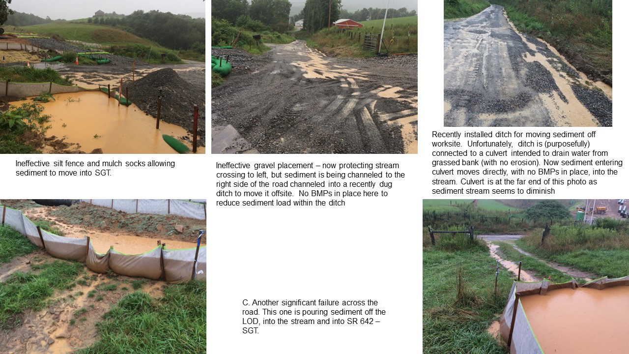
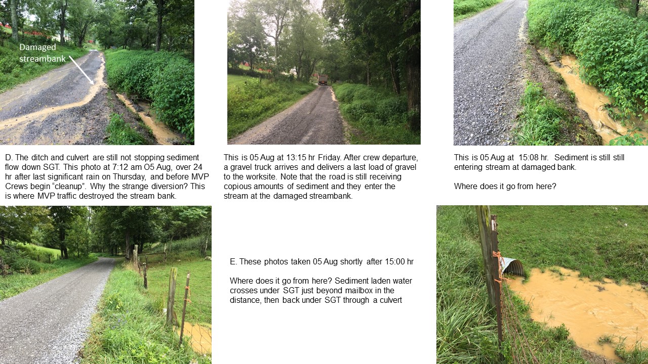
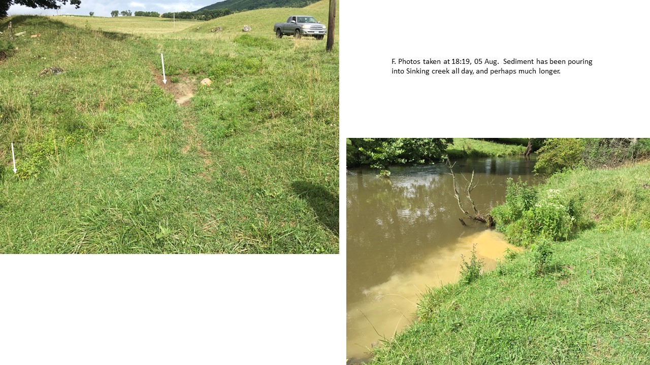
On 03 Aug, BMPs began failing. Except those labeled otherwise, the following photos were taken on 05 Aug after 12:50 p.m. after MVP erosion-emergency crews had “cleaned-up and departed for the day. At this point MVP clearly had more than 24 hours to respond to the major storm events earlier in the week. Note: SGT refers to Stevers Gap Trail.
A. Pipeline centerline and working/parking area at southern terminus of MVP work site. Sediments were actively flowing from up slope pipeline areas. BMPS in place included over-sized slope breaks with deeply dug sediment traps at the ends. Silt fencing and mulch-filled socks were in place to retain any sediment escaping from the primary control structures. (Figure 4)
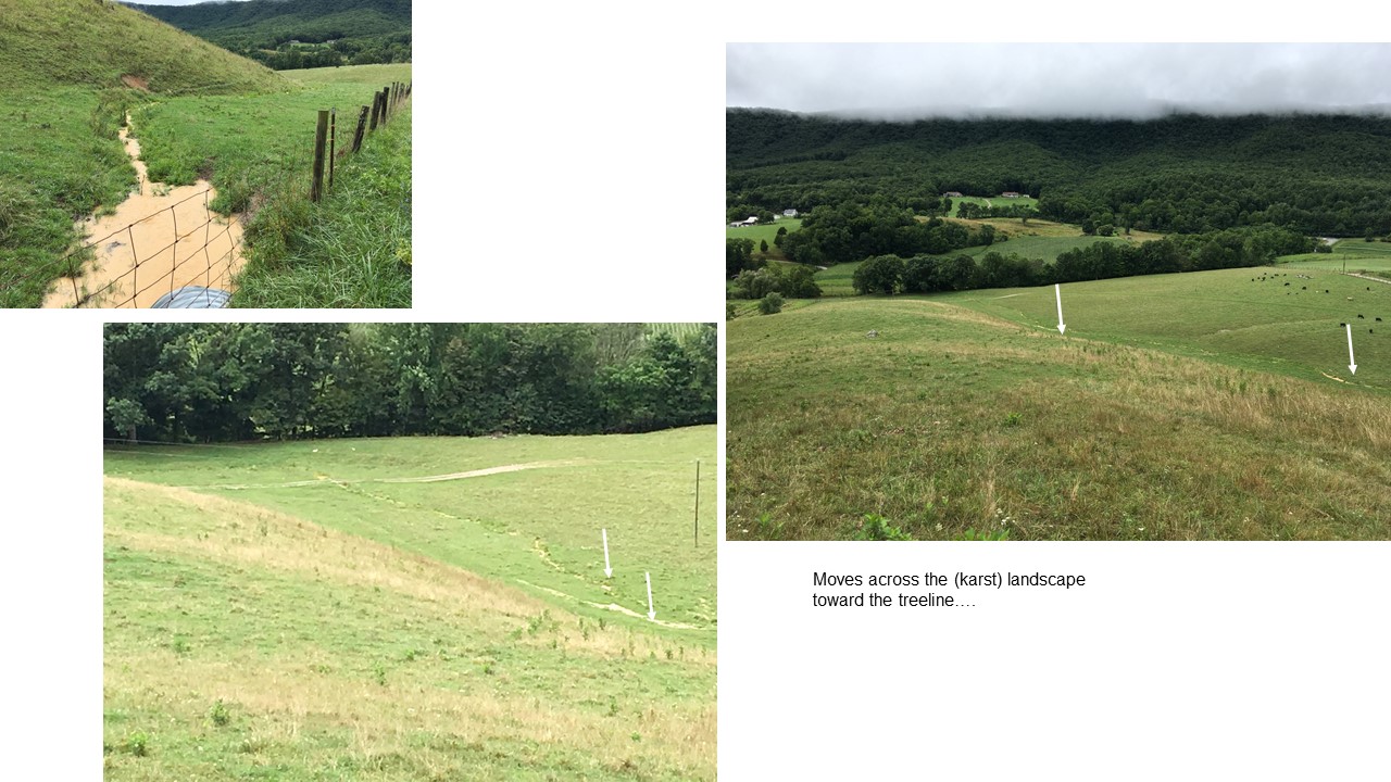
B. Sediment flow continues moving northward down SGT toward Sinking Creek 2300 feet away (map length). Sediment load actually increases as dried mud layers below gravel is wetted and detach. Again, these photos are taken after MVP crews left the site on Friday afternoon, over 30 “working” hours after the last significant rainfall ended early Thursday morning. (Figures 5-8)
Appendix 1: Rainfall at this site
| Date | Rainfall (in) | Storm Frequency |
|---|---|---|
| 6/9/2018 | 0.36 | <2 year |
| 6/12/2018 | 0.04 | <2 year |
| 6/14/2018 | 0.02 | < 2 year |
| 6/20/2018 | 0.82 | < 2 year |
| 6/21/2018 | 0.02 | < 2 year |
| 6/22/2018 | 0.05 | < 2 year |
| 6/23/2018 | 0.09 | < 2 year |
| 6/26/2018 | 0.15 | < 2 year |
| 6/27/2018 | 0.53 | < 2 year |
| 6/28/2018 | 0.09 | < 2 year |
| 7/7/2018 | 1.34 | 2 year |
| 7/8/2018 | 0.04 | < 2 year |
| 7/17/2018 | 0.04 | < 2 year |
| 7/18/2018 | 0.14 | < 2 year |
| 7/22/2018 | 1.24 | 2 year |
| 7/23/2018 | 0.27 | < 2 year |
| 7/26/2018 | 0.35 | < 2 year |
| 7/31/2018 | 0.3 | < 2 year |
| 8/1/2018 | 0.22 | < 2 year |
| 8/2/2018 | 0.16 | < 2 year |
| 8/3/2018 | 1.51 | < 10 year |
| 8/4/2018 | 1.24 | < 10 year |
| 8/5/2018 | 0.01 | < 2 year |
| 8/7/2018 | 0.36 | < 2 year |
| 8/8/2018 | 0.01 | < 2 year |
Dates not shown had <0.01” ppt.
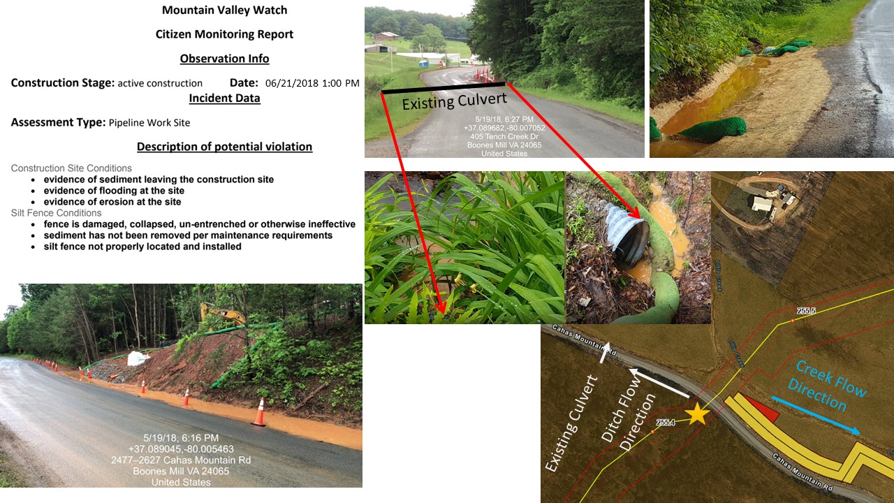
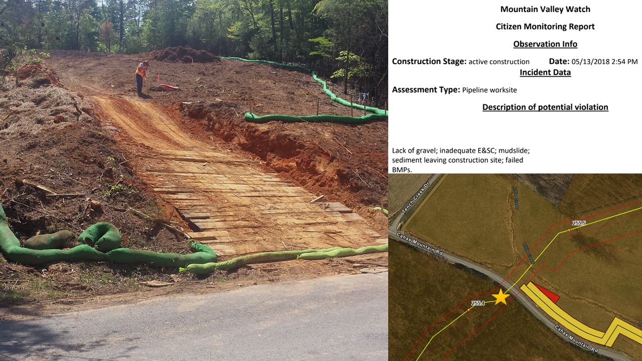
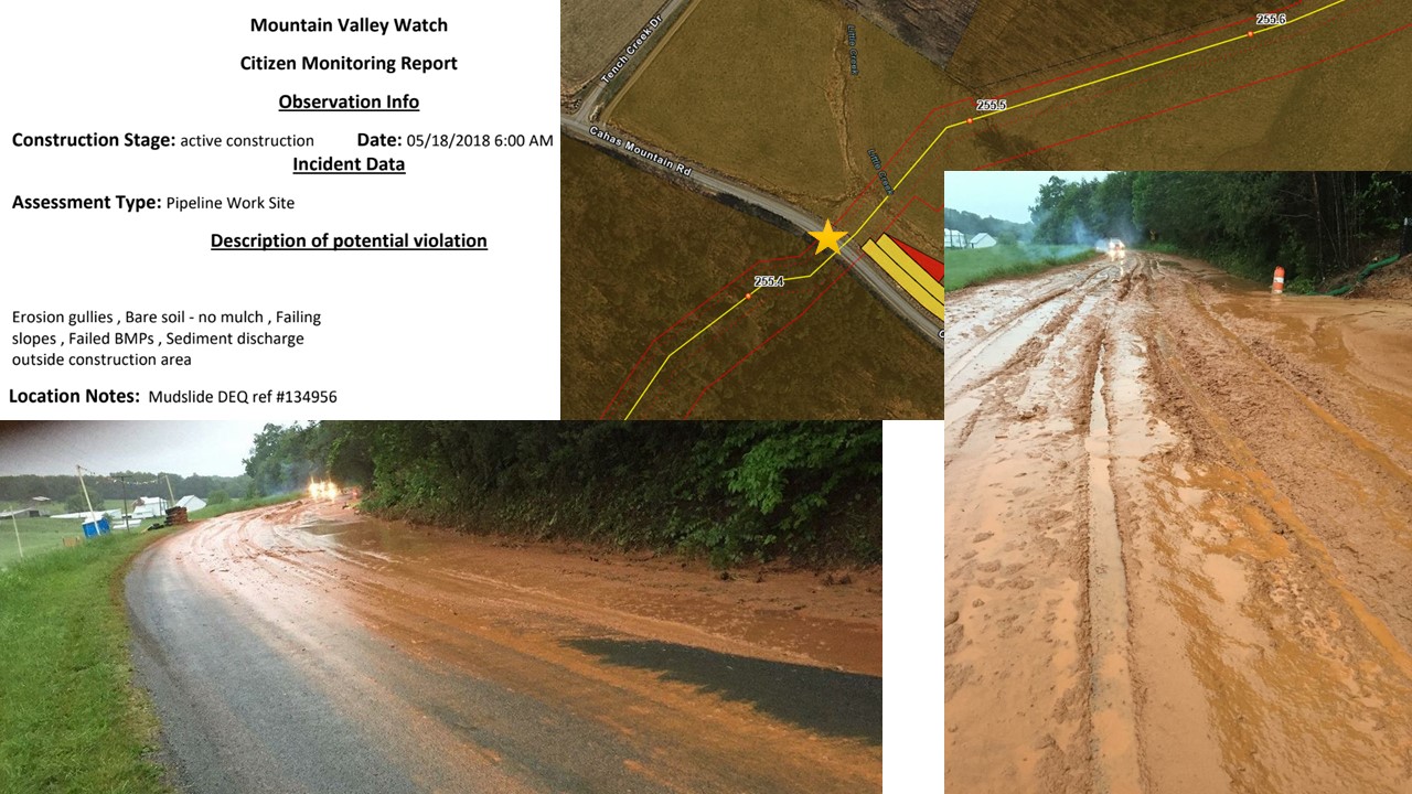
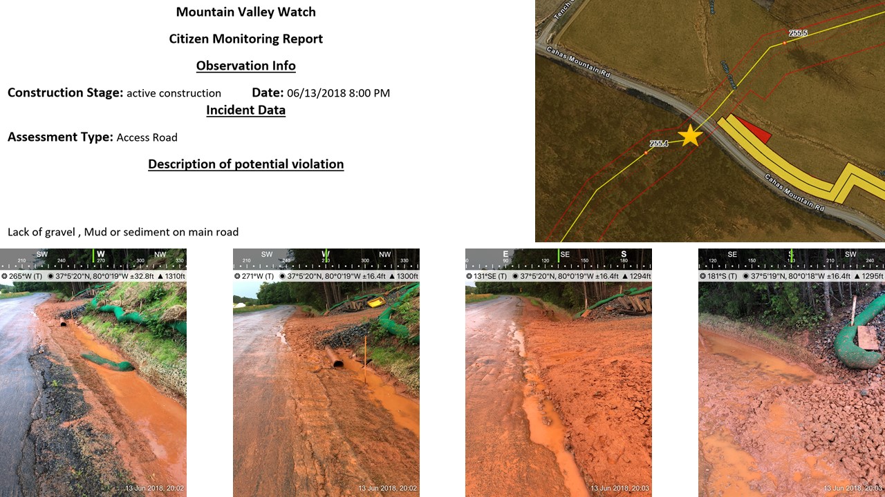
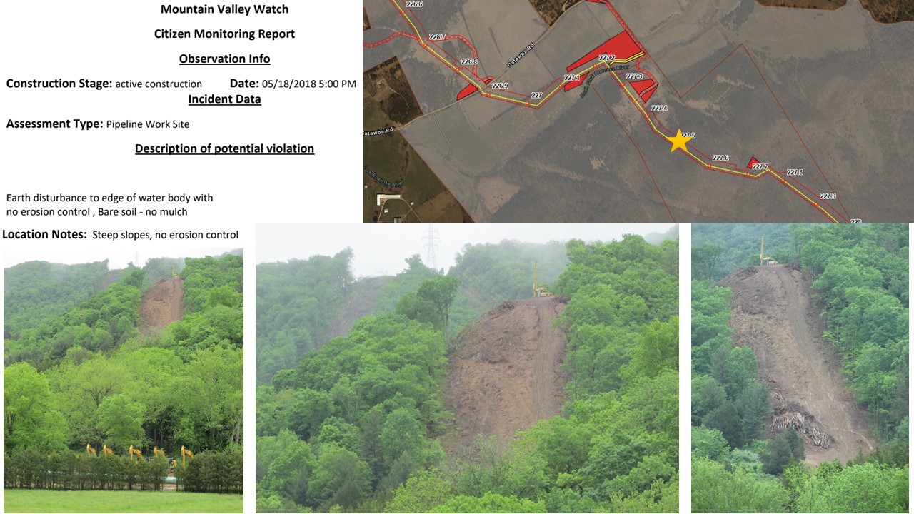
Case Study 2: Flora Property
Cahas Mountain Road – Franklin County Virginia
The first major impact to this location was on May 18, 2018 when a mudslide occurred on a 23% slope causing major impact to Little Creek. Approximately one foot of mud covered Cahas Mountain Road. Precision Pipeline, the MVP contractor constructing the pipeline, attempted to repair and mitigate the damage by shoveling the mud upstream to the roadside ditch, which then flowed to an existing culvert under Cahas Mountain Road and into Little Creek. During successive rain events, additional mud impacted Little Creek. See figures 10-13 for graphics explaining the mudslide event and flow path (black arrow to existing culvert). Additional pictures in figure 9 show the existing culvert location with a black line and red arrows to pictures of the up and downstream invert locations. Sediment can be seen entering the up invert and discharging into the creek at the down invert. Violations reported at this location show a series of repeated BMP failures and inadequate construction entrance on Cahas Mountain Road.
Cahas Mountain slopes are 23%, significantly less than what will be experienced in the North and South Fork Roanoke River watersheds which are in excess of 82.4% above crossing S-C21 (MP 230.7) Bradshaw Creek; 67% and 88.8% slopes in the Sawmill Hollow-Roanoke River watershed impacting S-NN16 (MP 235.4) Roanoke River; as well as 71.1% slopes in Brake Branch-South Fork Roanoke River that will directly impact the sections of the Roanoke River that serve the largest populations. Traditional erosion control practices are not effective on construction sites exceeding a 15% slope with slope lengths of 75 feet or greater. MVP project site erosion controls were and will continue to be overwhelmed. (D’Ardenne, D. 2018)
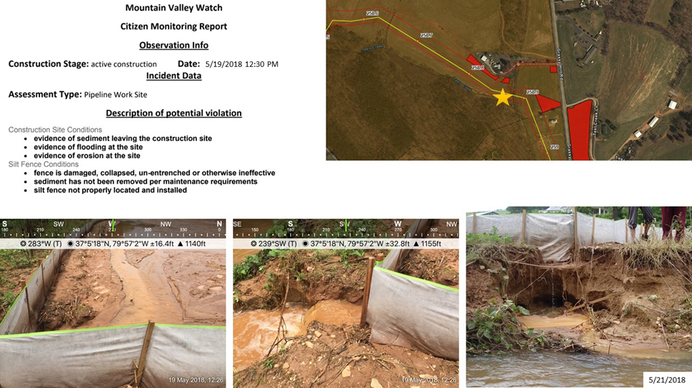
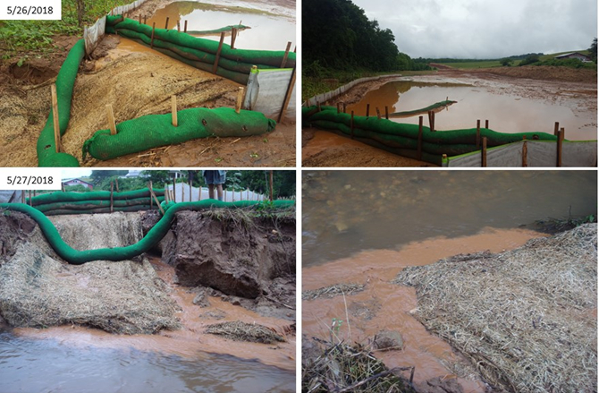
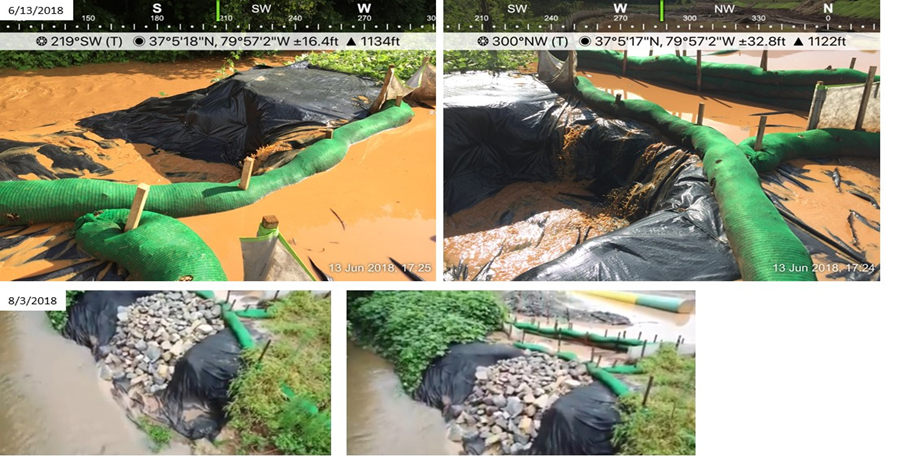
Case Study 3: Bernard Property
Grassy Hill Road – Franklin County Virginia
The recurrent failures at this location adversely impact the floodplain adjacent to the Bernard residence, including Teels Creek. USACE NWP12, General Condition 12 mandates, “Appropriate soil erosion and sediment controls must be used and maintained in effective operating condition during construction.” Figures 14-16 below show a time series of repeated failures of the stream bank on Teels Creek. The silt fence was installed too close to the creek. When it rained, runoff from the large contributing drainage area accumulated at the low point of the construction corridor adjacent to the creek. The weight of water being held back by the silt fence created a piping effect, undermining the silt fence. The resultant gully became larger with every rain event and repair attempt. Sediment flowed freely into Teels Creek on several occasions.
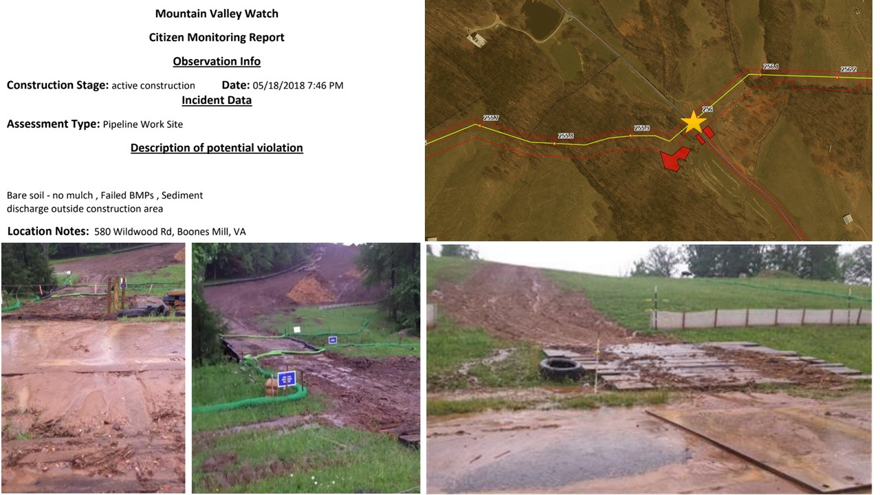
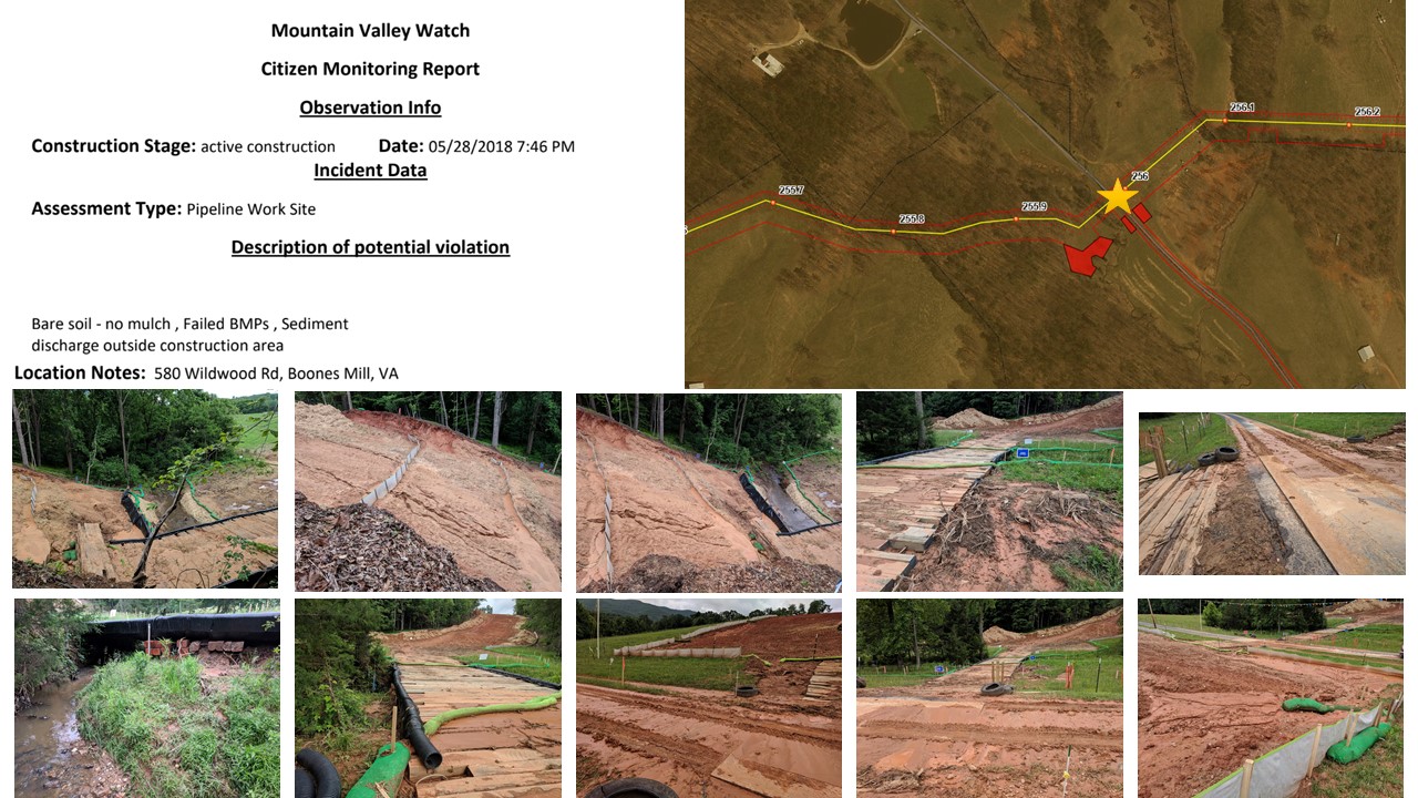
Case Study 4: Frith Property
Wildwood Road – Franklin County Virginia
Temporary right-of-way diversions (RWD) were not properly installed. Per Std & Spec 3.11 of the Virginia Erosion and Sediment Control Handbook, 3rd edition, minimum allowable height of RWD is 18″, 6′ minimum width, shall be constructed of compacted soil, must have a stabilized outlet and immediately stabilized per Minimum Standard (MS) 5.
RWDs in this section have been breached repeatedly due to improper installation on steep slopes and recent rains. RWDs do not meet the minimum size requirements, are not properly compacted, are not stabilized, nor do they have a stabilized outlet.
Holes were excavated by the contractor at the discharge point of each RWD to trap runoff which are not properly sized for the contributing drainage area; do not provide a stabilized outlet; discharge directly to silt fence which is installed perpendicular to the contour, resulting in gully erosion. Per MS-19, ‘concentrated stormwater runoff leaving a development site shall be discharged directly into an adequate natural or man-made receiving channel.’ The trenches in this section have filled with sediment causing the RWDs to breach, consequently overtaking ESC measures downgrade and impacting downstream properties and waterways.
See Figures 17 and 18 for potential violations reported on May 18, 2018 and May 28, 2018.
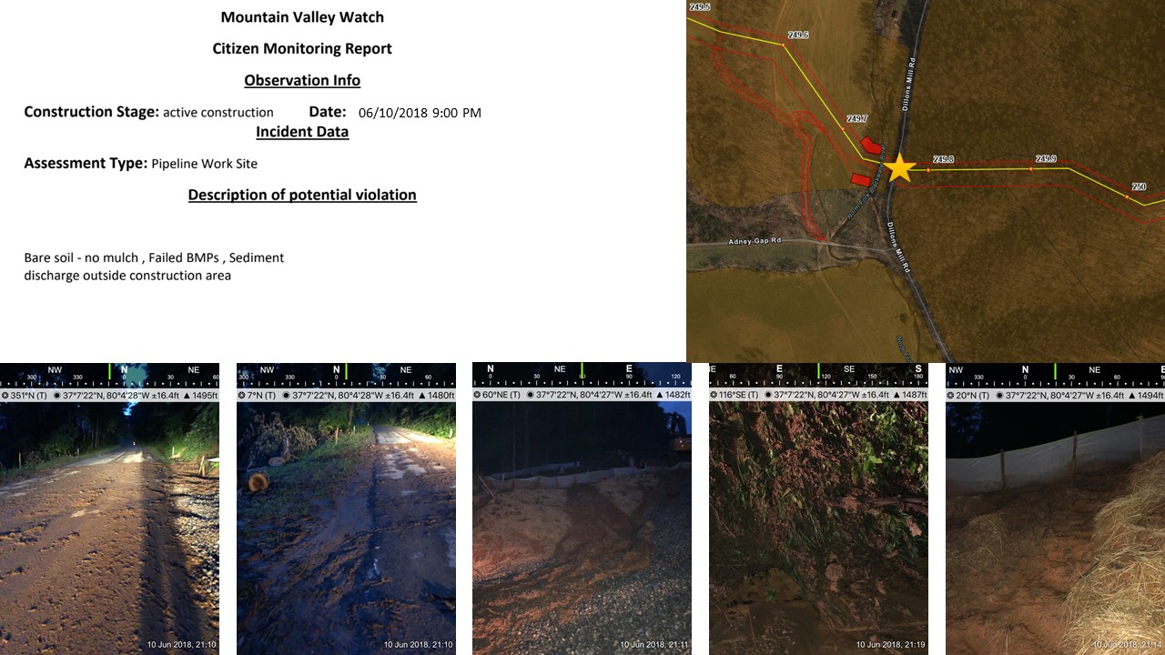
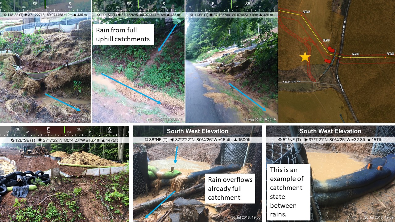
Case Study 5: Dillons Mill & Adney Gap
Franklin County Virginia
Temporary right-of-way diversions (RWD) were not properly installed. Per Std & Spec 3.11 of the Virginia Erosion Control Handbook. Violation reported – June 10, 2018
Case Study 6: Blue Ridge Parkway
Roanoke County Virginia
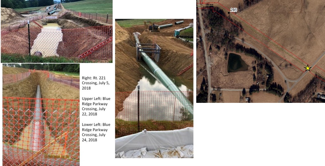
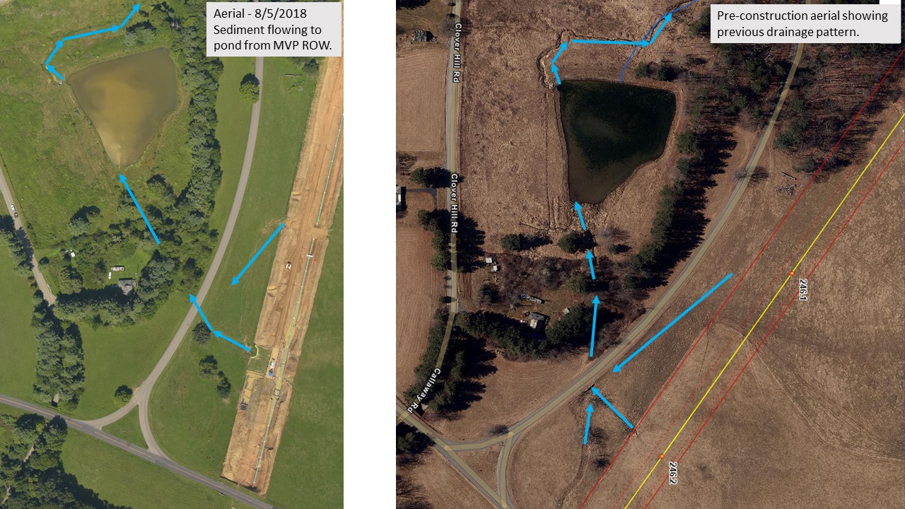
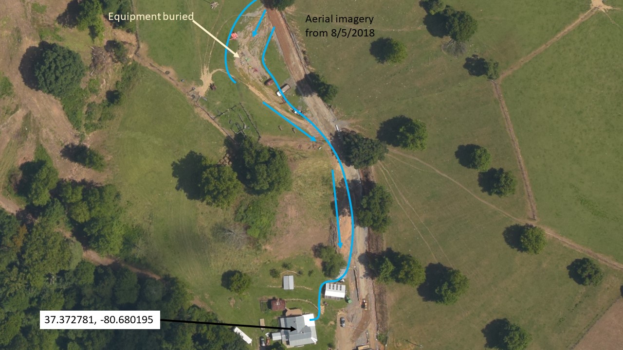
The perched aquifer has been breached at the Blue Ridge Parkway crossing. During both rain events and dry periods, the pipe beneath Route 221 and the Blue Ridge Parkway has been submerged in groundwater that continues to pool in the trench. This perched aquifer is the groundwater for the Bent Mountain community, and feeds residents’ wells — their only source of drinking water. Dr.Pamela Dodds, an expert hydrogeologist, prepared a report on the perched aquifer of Bent Mountain in which she stated that “deforestation, soil compaction, and dewatering [during pipeline construction] will permanently deplete groundwater flow through perched aquifers in the Mill Creek watershed to seeps and springs that provide water to wetlands, headwater areas, stream baseflow, and residential wells, and will permanently reduce the groundwater hydraulic gradient.” (Dodds, P.C. 2017) See Figures 21 and 22 for location of the Blue Ridge Parkway crossing, pictures of groundwater in the trench, and an aerial photo showing sedimentation of source water point for Mill Creek.
Case Study 7: Parsons-Sink property
Catawba – Montgomery County Virginia
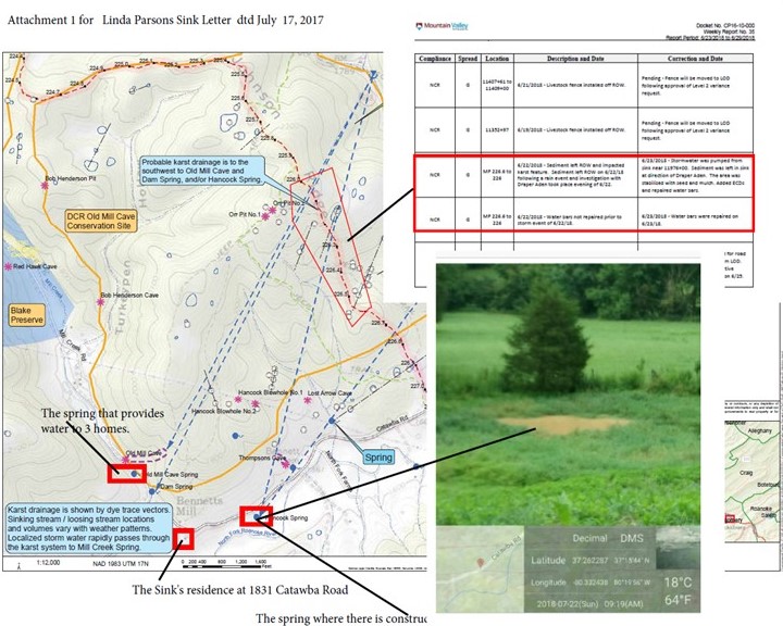
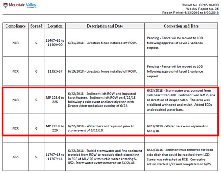
Sedimentation impacts to springs in Catawba have been recorded since construction began on the MVP. Previous dye traces by the Department of Conservation and Recreation link Dry Run to springs on the Sink property. Dye trace lines are visible in figure 23 dashed with an arrow on end showing trace direction. Existing fissures or new fissures developed from construction activities such as blasting could contaminate drinking water sources. Springs in the dye collection area provide drinking water to three residences.
Case Study 8: Dyer, Jones, Powell, Slayton, & Triplett Properties
Brush Mountain – Montgomery County Virginia
Multiple failures along steep slopes that drain to the Slusser’s Chapel Conservation area. Reported violations for SMN21 and map of SMN22 are shown below. Over the course of construction, there have been multiple major observed incidents on the Slayton, Powell, and Jones properties on Brush Mountain in the Slusser’s Chapel Conservation area. The first set of violations shown below, reported to MVW June 22 and 23, 2018, included significant silt fence and compost filter sock failure that resulted in sedimentation leaving MVP’s work site and entering streams SMN21 and SMN22.
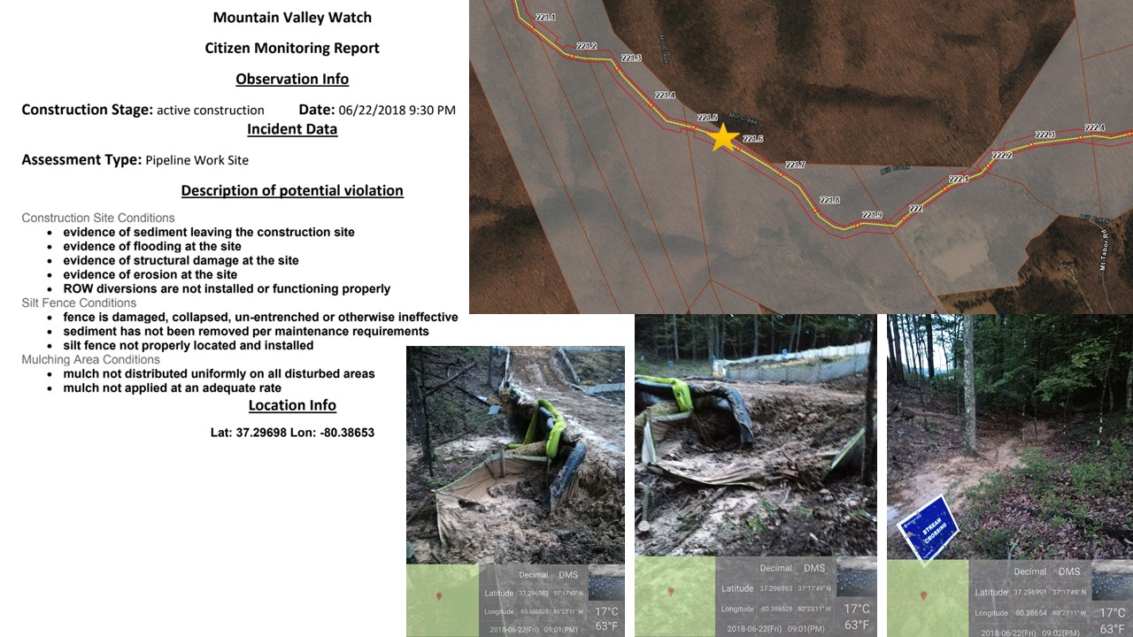
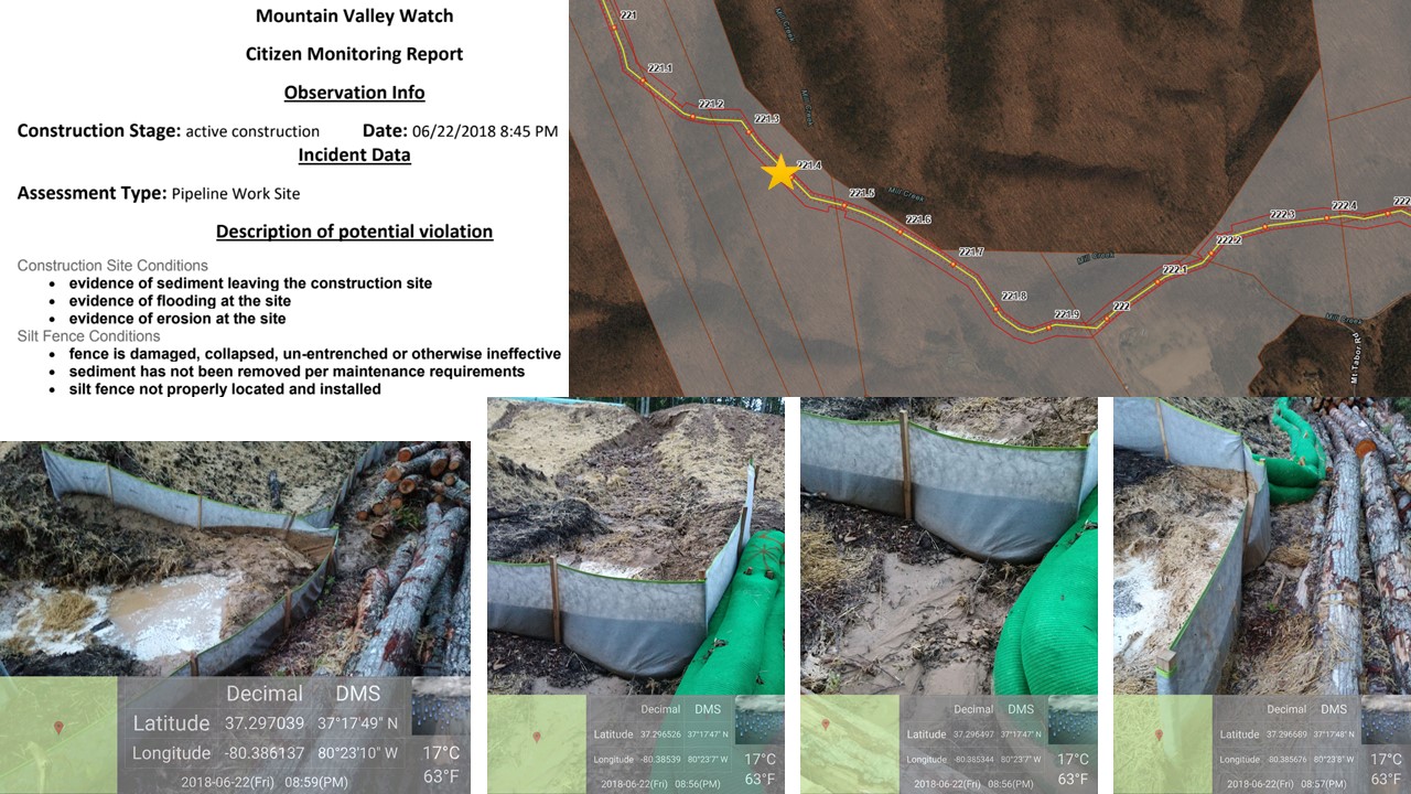
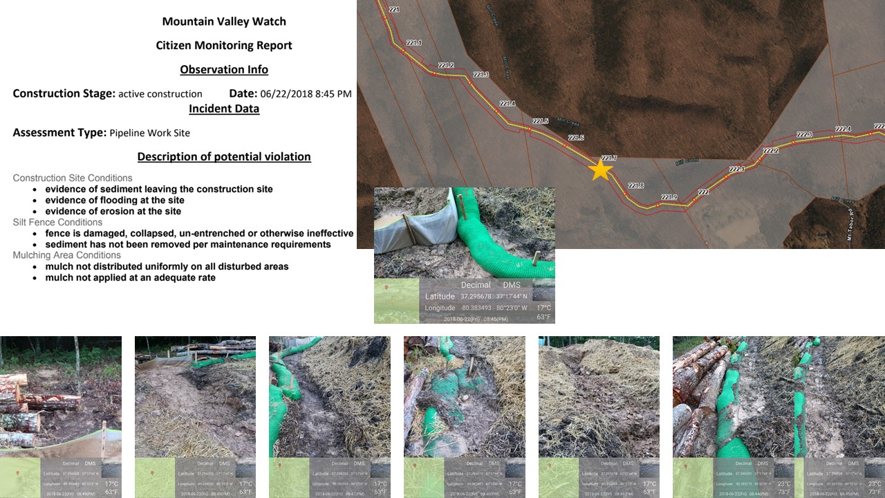
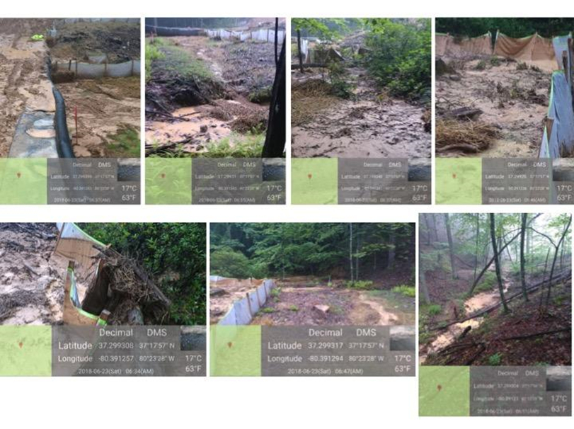
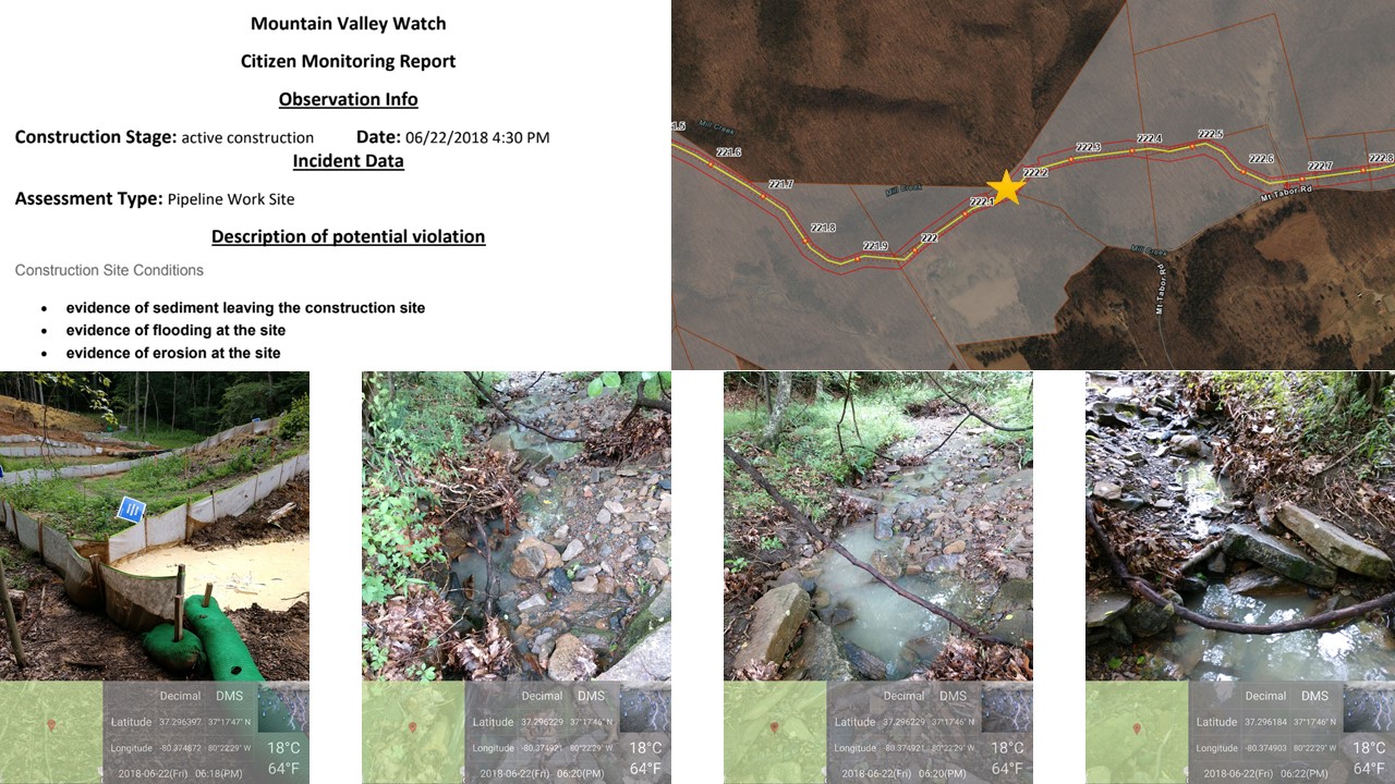
Failures in the area continued to June 26, 2018 on the Dyer property, shown in three photos below where sediment is leaving MVP’s construction right of way.
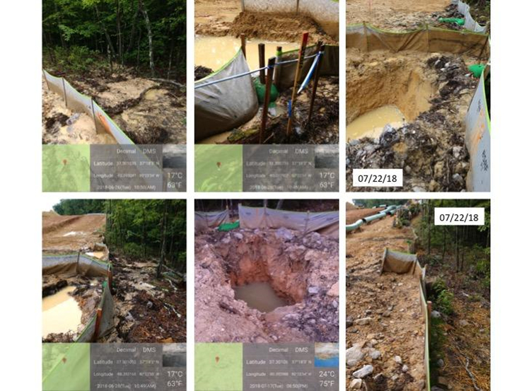
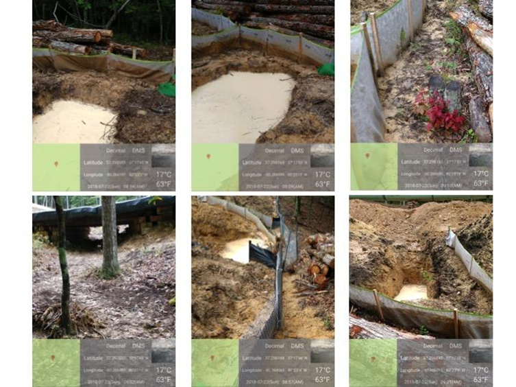
Despite DEQ’s issuance of a Notice of Violation July 9, 2018 and MVP’s subsequent voluntary stop work to repair ESC measures, the Slusser’s Chapel Conservation area continued to see erosion and sediment control incidents, with additional ESC failures reported on the Dyer property July 17 and July 22, and on the Slayton property July 22, 2018. The images shown below are from those reports. One image in figure 31 from the reported incident on the Slayton property shows the stream bed clogged with mud as a result of repeated failures.
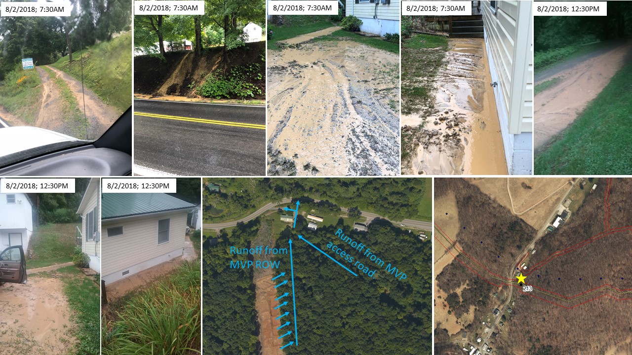
Case Study 9: Historic Newport
Giles County Virginia
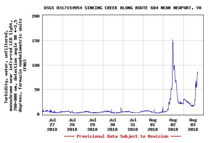
This is the first major failure observed in Historic Newport Virginia. This is the pattern for future rain events and impacts to Sinking Creek. See images of potential violation below. The drainage area for stormwater runoff includes a portion of an access road and a large area from the MVP right of way. Overwhelmed outlet structures at the discharge point of diversion bars cause rain water to create new runoff gullies adjacent to the ROW. Runoff from the access road combines with ROW runoff and result in the sedimentation shown in figure 33. A snapshot of the USGS water quality gauge, figure 34, located 1.71 miles downstream in Sinking Creek indicates a large spike in sediment loading on August 2, 2018.
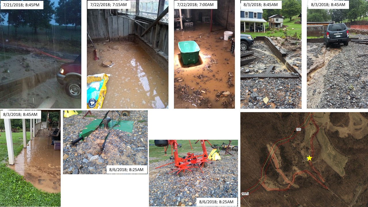
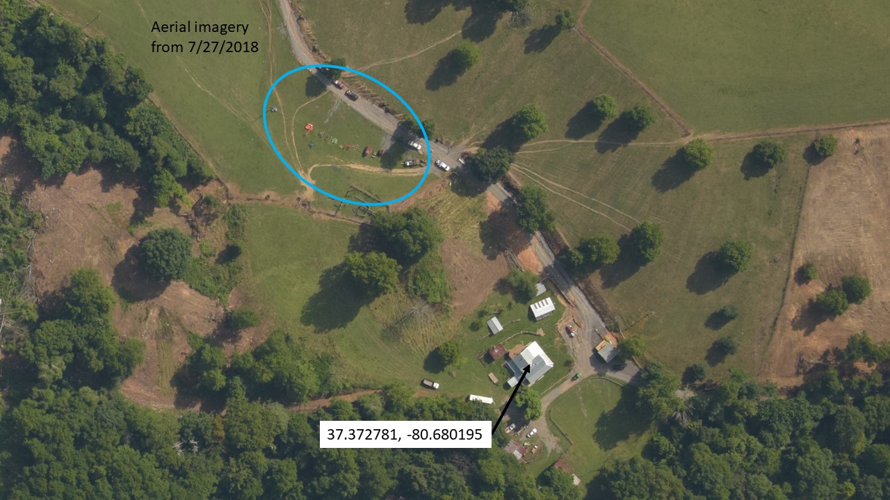
Case Study 10: Gallagher Property
Giles County Virginia
As of the writing of this report, three major failures (on 7/21, 7/31 and 8/2) had occurred at the Gallagher property. Grading for an access road redirected runoff toward the house and chicken coop. Both the chicken coop and basement of the house were flooded. Figures 35-37 illustrate the resulting damage. As part of the continued updating of this report a fourth and the most significant failure to date occurred 8/13/2018. We are collecting images and will update report.
Part II: Relative Effectiveness of BMP
Literature reviews of Peer Reviewed Publications
Evidence of the peril posed by construction of large gas pipelines, through the Valley-and-Ridge, Blue Ridge, and Piedmont physiographic provinces, is found in the extant literature – a multitude of studies on the efficacy of BMPs published in refereed academic journals. It address most aspects and types of BMPs though there is relatively little research providing quantitative indicators of the efficacy for specific E&S control devices. Much of this research is addressed in recent literature reviews (Cristan et al., 2016; Anderson and Lockaby, 2011; Edwards, and Williard, 2010; Aust and Blinn, 2004). Reports typically are organized by physiographic regions; for example: coastal plain, piedmont, and mountainous.
In general, BMPs have proven to be effective (when compared with prior practices) for reducing adverse effect, while being practical and cost effective, if they are properly installed and maintained (Aust et al., 2016). – conditions too often visibly unfilled by Precision Pipeline.
However, the efficacy of a properly deployed BMP depends on a number of conditions, in addition to region: the type of device (e.g., silt fences, composite socks, diversion bars, check dams, stream management zones), type of disturbance (e.g., timber harvesting, road construction, skid trails and pipelines), local conditions (e.g., stream and wetland crossing, steep slopes, poor soils) and weather (rainfall). Findings from research in any one instance do not necessarily apply to another.
We limit our review to published research on the efficacy of BMP for heavily land disturbing activities in the Valley-and-Ridge region. Two earlier submission to the DEQ and the WCB – “The Scientific Consensus on the Threats Posed by Large Gas Pipelines to Virginia Waters: Compound Geo-Hazards” (Shingles, 2017, FERC #20170808-5015) and “Analysis of Geo-Hazards at Specific Water Crossings in Giles County Virginia” (Shingles and Shelton, 2018), detail the perils to subsurface waters in this karst laden region and the significance of the SWCB failure to include karst in its guidelines for the 30 day public comment period last Spring. There is no need to repeat that information. Here the focus is on the challenges posed to BMPs by mountainous terrain. Given the innately practical nature of BMPs, the pertinent questions addressed are:
(1) How effective are BMP when properly installed and maintained? and
(2) What are their limitations in the mountainous Valley-and-Ridge Region”?
The effects of stormwater runoff on erosion and sedimentation is greatest in mountain region (Austin and Blinn, 2004) where, normally dry intermittent streams that drain upland watersheds during heavy rains and ground saturation produce flash floods that reach sufficient velocity with increasing gradient to scour and move large amounts of soil, litter and fine debris downstream, adversely impacting perennial trout streams and ultimately larger bodies of water and wetlands (see watershed map below). Steeper slopes increase velocity and greater downpour and saturation increases volume, producing ever greater force and the likelihood of overwhelming best practices. The adverse impacts can take a very long time to dissipate (measured in months and years). A 16 years study of disturbed forest watersheds, due to tree harvesting and road construction in the Blue Ridge Mountains of North Carolina, which was coterminous with a period of intense rainfall, resulted in “significant increase in stream sediment” with long term adverse impacts (Austin and Blinn, 2004: 14).
The use of heavy mechanized equipment, of the type used in buried pipeline construction, on ridge tops and slopes with poor soils (e.g., high plasticity, poor drainage, shrink-swell potential and low bearing strength) creates widespread and severe soil disturbance, soil exacerbating erosion and sediment loading. (Anderson, 2011; Martin, C. W. and Hornbeck, J. W.: 1994; Hodges, 2016).
Stream order and spatial scale also effect BMP efficacy. “At the headwaters, ephemeral streams may be highly variable and much more responsive to surrounding conditions than larger watersheds.” (Anderson, 2011: 173).
In mountain terrain all these factor often occur together. “Because of the combination of steep slopes, erodible soils, and wide expanse, the Piedmont region has been referred to as the most problematic physiographic area in the Southeast in terms of BMP effectiveness [emphasis added]” (Anderson, 2011: 173 citing Williams et al. 2000).
Aust and Blinn find from their review of research that, with properly installed and maintained BMPs, the quantities of sediment introduced into streams tend to be “relatively low” and “acceptable” for alternative land use. (Aust and Blinn, 2004). However, BMPs may significantly minimize runoff on steep gradients and still fail to sufficiently protect water resources. For example, in one such study, total suspension solids (TSS) flux were found to increase 30-fold during timber harvests on 45% slopes with no BMP, but also increased 14-fold on areas with BMP compared with a control (Arthur et al., 1998). The challenge to best practices applied on steep slopes increases with the level of disruptive activity, extent of poor soils and amount of precipitation.
Two other studies (Sawyers et al., 2012, and Wade et al., 2012) conducted in the Virginia Piedmont, found the use of water bars designed to curtail erosion and sedimentation on steep slopes with overland skid trails were only modestly effective when not coupled with other erosion and control devices, mulch, hardwood or pine slash (Sawyers et al., 2012; Wade et al., 2012).
A study of the efficacy of diverter berms to control runoff on steep slopes found they failed “to prevent extensive rill and gully erosion, leading the authors to conclude that the available empirical methods were so impractical that they could not be used “with safety” for storms with a 10-year return period (Morgan et al., 2003).
Devices for diverting storm water from LODs are successful in creating new flow paths of sediment delivery into the forest. If not done carefully, effectively reducing flow in the LOD may solve one problem at the expense of creating another by directing sediment into highland tributaries. Best Practices require that this be avoided by protecting the outlet point with gravel or thick vegetation to reduce velocity and dissipate flow and by locating the LOD far enough from natural water courses (tributaries and wetlands) for the storm water to spread out and infiltrate the forest floor (Trimble and Sartz, 1957). However, as reported above, with Mountain Valley Pipeline construction, MVW has identified numerous locations where mud nevertheless overran the breakers and created new erosion gullies impacting natural water sources.
Improper siting of diversion bars and insufficient outlet control structures are not the only practice by Mountain Valley that do not conform with best practices. Precision Pipeline regularly installs silt fence at the toe of cleared slopes just before stream crossings, a practice best avoided according to one study (Wear et al., 2013). Other research indicate the best practice is the creation of Stream Management Zones (Anderson and Lockaby, 2011).
Conclusion
It is imperative that DEQ and the WCB reconsider the Nationwide Permit 12 and its certification that construction of the MVP does not pose an imminent, significant threat to Virginia Water. To the contrary, that premise is no longer (if it ever was) supportable by the facts. This report provides further evidence that the BMPs specified for use by Mountain Valley during construction are not adequate to protect Virginia’s water quality from sediment loading.