PDF of the report.
Introduction
In our December 2018 report we compiled examples of the most egregious violations we reported to the Virginia Department of Environmental Quality and the State Water Control Board. Since that report we have continued to compile citizen monitor surveys using Survey123 and publishing to ArcGIS online. Links to this report and applications highlighting various aspects of the project can be found on our website: Mountain Valley Watch mapping
The link to the Data Dashboard for mapping of reported violations is: Data Dashboard
Citizen Reports
Since our last report in December 2018 to the Water Control Board, a total of 32 citizen submissions have been compiled in our database as of 4/1/2019. Volunteers have consistently documented overwhelmed erosion and sediment control devices throughout every county in Virginia. For reference, since the beginning of the Mountain Valley Watch program, our dashboard has compiled 562 reports of issues occurring along the Mountain Valley Pipeline. Though reports through surveys have slowed in the winter months along with pipeline construction, the massive number of total reports over 2018 and 2019 indicates a complete disregard of the erosion control regulations along the MVP route. Figure 1 shows incidents reported in the Mountain Valley Watch Dashboard from 1/1/2018 – 4/1/2019.

Notable Incidents
A review of areas having recurrent issues shows locations continue to see erosion and sedimentation issues. Piloted flights on September 18, October 12, November 11, 2018 and March 28, 2019 reveal a number of incidents. The next sections will highlight specific locations along the route, sometimes with additional field support pictures, to give a more complete overview of the incidents observed.
Cahas Mountain Road Crossing — Garst Property
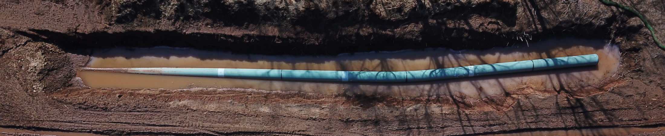
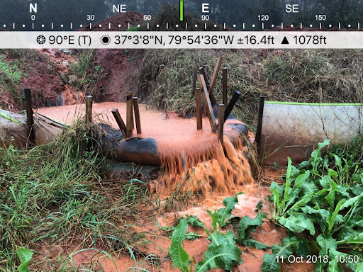
The crossing of Cahas Mountain Road on the Garst Property in Franklin County, Virginia has seen repeat failures over the course of at least six months. Figure 2 shows an aerial photo of the area in question from March 28, 2019, highlighting the location of ongoing ESC failures. This area drains to the North Fork of the Blackwater River. Figure 3 shows an incident reported September 17, 2018 of a stream of sediment overrunning the erosion controls at the perimeter of the right-of-way. Figure 4 shows the right-of-way uphill from the failed perimeter controls in Figure 3, with a lack of adequate stabilization in January 2019. Figure 5 shows the same area with similar problems occurring February 21 and 24, 2019.


Grassy Hill Road — Bernard Property
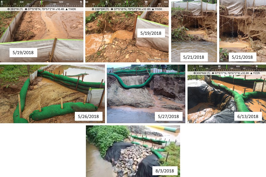
Another site that has seen ongoing stabilization issues is the Bernard Property on Grassy Hill Road. Previous reports to the DEQ and Board have included multiple images of the failing banks of a tributary and Teels Creek, notably in May and June 2018 when MVP crews used black tarps to prevent large volumes of mud and sediment from eroding the creek bank and entering the waters of Teels Creek and its unnamed tributary. These failures are a result of ponding water near the edge of the ROW which was installed too close to the stream bank. The additional weight from ponding water caused piping to occur and subsequent erosion and failure of the bank along Teels Creek. Figure 6 below, shows a sequence of photos leading to the bank failure from late May and June of 2018. In Figure 7 below, note the continued erosion of the stream bank despite the jute fabric and perimeter controls present. Additionally, the photos to the left of Figure 7 show a compost filter sock that fell into the stream and was subsequently put back on the collapsed bank by MVP crews, rather than being replaced — particularly notable due to the holes and tears in the filter sock. This site in particular is an example of construction plan design flaws that did not take stream bank proximity and ROW drainage areas into account when installing the perimeter controls. This led to ineffective maintenance and replacement of ESC measures that continue to fail at this location.

Iron Ridge Road — Angle Property
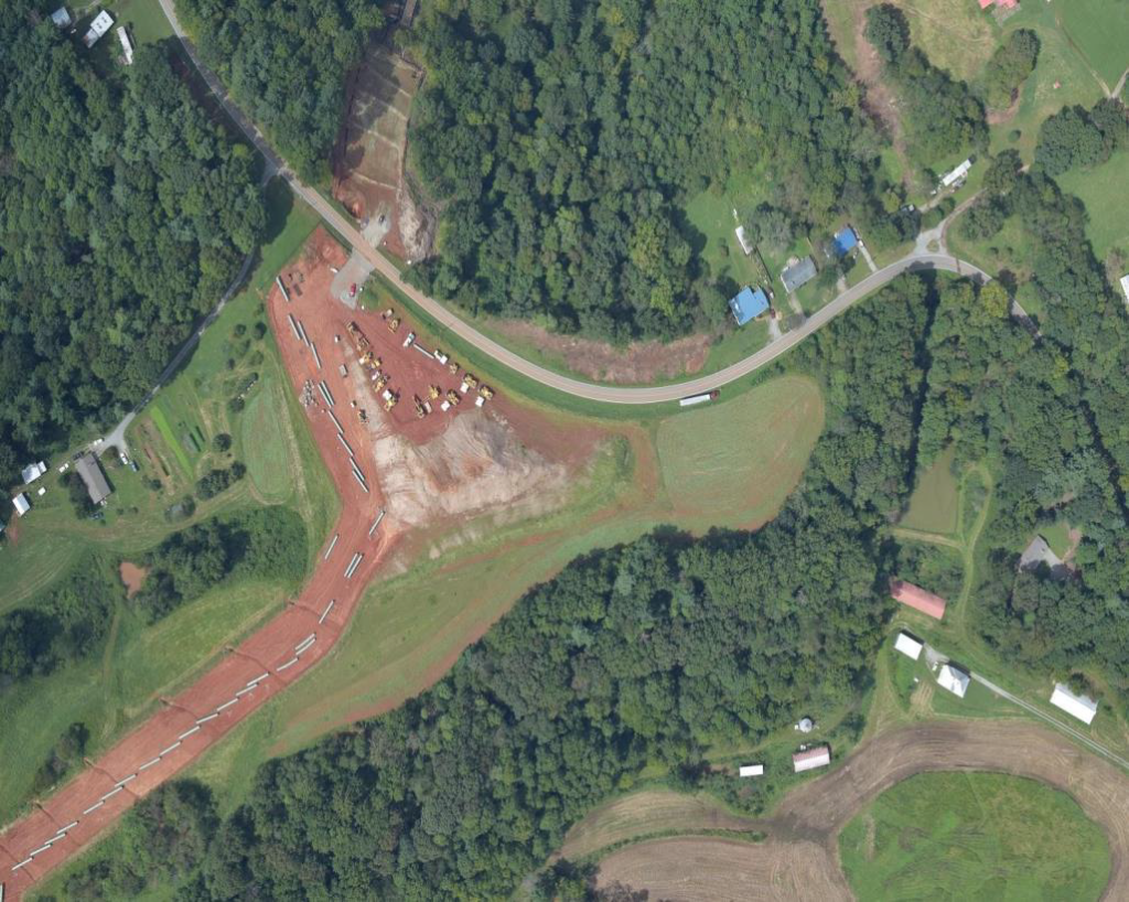
Over the course of several months, MVP’s lack of stabilization on the Angle property — particularly on the pyramid of earth and large workspace near the crossing of Iron Ridge Road — has caused repeated sedimentation events off the right of way, including sediment flowing into the Angles’ pond, Little Creek, and the Blackwater River. This earth pile was left unseeded and was not maintained through the winter, despite a lack of construction activity on the property. Combined with unmaintained ESC measures, the Angles’ pond has been filled with sediment since May 2018, through both heavy storms and regular rain events. Figures 8 and 9 show images of unseeded earth from the ground and air through winter and into spring. This site and its ongoing issues have been described to the Board in previous reports, were seen in person by visiting Board members, and remained in this condition leading up to and after the March 1 Board meeting.
The Angle property was also impacted by the use of erosion control pellets, which were dropped on the farm’s slopes both on and off the right of way before crews left for the winter, and most of the pellets were blown from the site by wind.


Figure 9: Images of bare earth and failing silt fences on the Angle property through March and April 2019. The right of way crosses Little Creek at the treeline in the image to the left. Note hole in silt fence, downhill from unsecured earth, which has remained in this condition leading up to and in the weeks following the March 1 Board meeting.
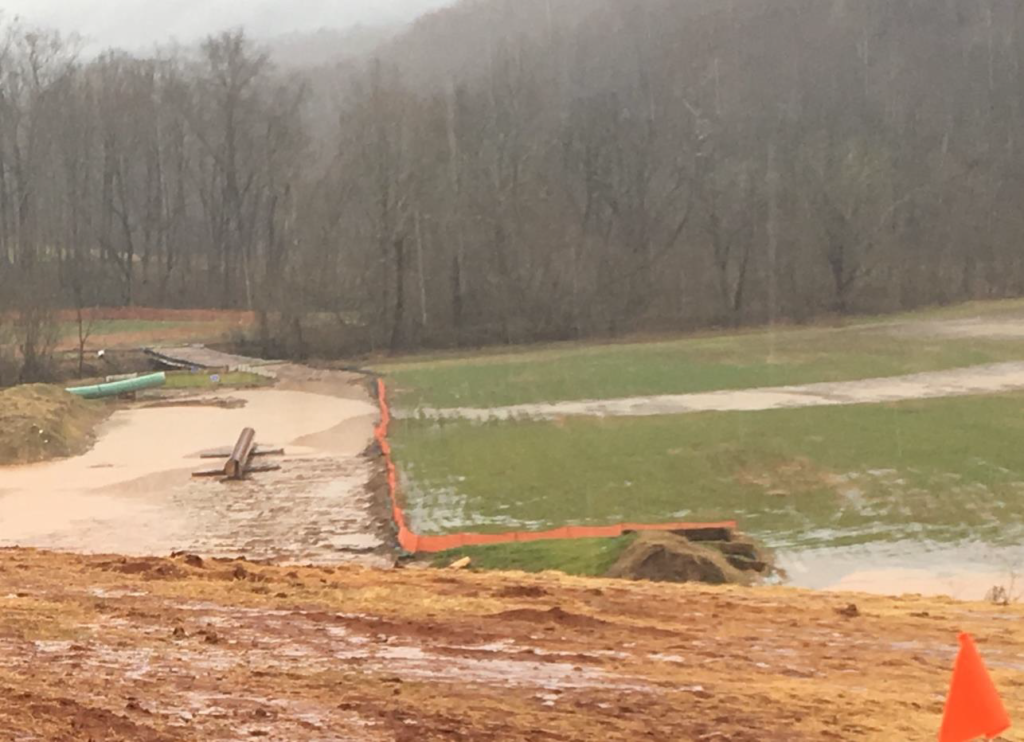
The photo below (Figure 11) shows significant sections of bare, unstabilized soil that has been in that condition since October 2018. In the foreground is a “water bar” which is intended to channel water across the right-of-way to the settling basin seen in the lower right corner. Note that this water diversion structure is itself unstabilized and contributing eroded soil to the flows leaving the site.
Cahas Mountain — Ridge Between Webster Corner Road and Cahas Mountain Road
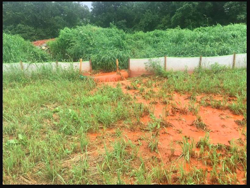
The ridge of Cahas Mountain has seen ongoing issues with sedimentation off the right of way and lack of stabilization through the winter months, during which little to no construction work was ongoing. Sedimentation from this site flows downhill into a stream.

Helicopter Flyovers
In numerous areas along the route, residents have reported low-flying helicopters over the pipeline right-of-way, some carrying bags of erosion control seeding pellets to drop on bare earth. These aircraft have been spotted flying below the treeline. It should be noted that the helicopters are impacting private property, residents, livestock, and crops in these rural communities. This method creates an atmosphere of constant surveillance and intimidation for those who live along or near the pipeline route.

These helicopters are used to spread erosion control pellets called EarthGuard on the right of way. However, reports from both West Virginia and Virginia indicate that this method of spreading pellets is imprecise and results in pellets being dropped into streams and waterways. A lawsuit was filed in West Virginia against MVP alleging that the pellets landed off the right-of-way on the property of an organic farm and violated conditions for organic certification. The GHS Safety Data Sheet for EarthGuard pellets indicates they contain acrylamide, which is known to cause cancer, birth defects, and other reproductive harm.
Seeding by helicopter does not meet Standard and Specification 3.31, Temporary Seeding, in the Virginia Erosion and Sediment Control Handbook. Seedbed preparation requires liming, fertilization and surface roughing or tracking of seedbed before planting seeds. No seedbed preparation was performed before seeds were dropped from helicopters.
Seeding by helicopter raises the question of approved methods for temporary seeding. STD & Spec 3.31 does not mention seeding by helicopter as a method approved by DEQ. Was a variance approved by DEQ that allows for temporary seeding using helicopters? If not, then this issue should be revisited and a variance submitted to DEQ for approval.
Minimum Standard 1 requires that “Temporary soil stabilization shall be applied within seven days to denuded areas that may not be at final grade but will remain dormant for longer than 14 days”. The photos in this report show that many areas along the pipeline right-of-way do not have grass growing as required for periods of construction inactivity. In addition, Minimum Standard 2 requires that “The applicant is responsible for the temporary protection and permanent stabilization of all soil stockpiles on site”. Photos in this report show several soil stockpiles that have no stabilization on them.
Regulatory Context
Responses from State Agencies
West Virginia Department of Environmental Protection has issued 27 Notice of Violations for the Mountain Valley Pipeline as of April 3, 2019.
In July, 2018, the Virginia Department of Environmental Quality (DEQ) issued a Notice of Violation to MVP citing violations identified during the May and June complaint investigations and inspections. Despite over 300 violations cited in the Attorney General’s suit against MVP filed in December 2018, no additional Notice of Violations have been issued.
From 10/25/18 to 4/8/19, Virginia DEQ documented 54 incidents of erosion problem areas in the PReP incident reports database for the MVP. The majority of problems recorded were inadequate stabilization measures, overwhelmed ESC measures, failure to maintain erosion control devices, standing water in trenches or on the right of way, ongoing construction in wetlands despite missing Army Corps authorization, and sediment leaving the pipeline right of way and entering streams and wetlands.

State Lawsuit Against MVP
In Mark Herring’s lawsuit filed on behalf of DEQ and the Water Control Board in December 2018, 16 DEQ inspections found violations between May 21 and October 17. From the beginning of June through November 15, MBP inspectors contracted through DEQ found 180 instances in which MVP failed to meet erosion and sedimentation standards and failed to repair issues within 24 hours of citation.
The suit requests that the Court do the following:
- Order MVP to immediately come into compliance with State Water Control Law, the Virginia Stormwater Management Act, the Virginia Erosion and Sediment Control Law, and the Board’s regulations;
- Assess a civil penalty against MVP to the maximum allowed by law;
- Award DEQ and the Board costs and reasonable attorneys’ fees; and
- Grant any and all further relief that the Court deems just and proper.
DEQ has since reported that MVP has come into compliance with the relevant regulations on the issues filed in the lawsuit, which renders the first request essentially moot. If the second and third requests of the lawsuit are granted, any money awarded will go to the state to use as it sees fit, not to any of those impacted directly by damage done. Unless the Court determines that the violations of law are so egregious as to require the revocation of the 401 Certification altogether, the residents of Southwest Virginia impacted by this pipeline can expect no relief, meaningful or otherwise, to result from this lawsuit.
FERC Compliance Context
The Roanoke Times published an update on MVP’s compliance reports from FERC inspectors March 31, 2019. In this report, local journalist Laurence Hammack found that MVP had reported that environmental compliance monitors found the following up to March 9:
- “2,724 acceptable reports – no problems found.
- “1,564 communication reports – issues that came to the attention of FERC monitors and were resolved through meetings with construction crews, landowners or other agencies.
- “36 problem area reports – an activity that is not acceptable, but is not considered a noncompliance of regulations.
- “45 noncompliance reports – activity that violates regulations, results in damage to resources, or places them at risk.
- “0 serious violation reports — activity or compliance failures that caused substantial harm or serious threats to a sensitive area or species. Determined on a case-by-case basis, serious violations can lead to a formal enforcement action by FERC, such as a fine or stop-work order.”
Of particular note in the article, however, is the statement that a contractor working for MVP in Pittsylvania County reported in February that erosion maintenance repairs had been made, when they had not. The contractor filed a false report which is indicative of a trend to falsify information concerning erosion control violations.
The report from the Roanoke Times gives a summary of the kind of enforcement that the Board can rely on from federal agencies for this “federally-permitted” project, which is none. The lack of meaningful enforcement action taken by FERC in the face of falsified reports and inadequate work indicates little concern for Virginia’s erosion and sediment control regulations.
Conclusion
The purposes of the State Water Control Regulations are to:
(1) protect existing high quality state waters and restore all other state waters to such condition of quality that any such waters will permit all reasonable public uses and will support the propagation and growth of all aquatic life which might reasonably be expected to inhabit them;
(2) safeguard the clean waters of the Commonwealth from pollution;
(3) prevent any increase in pollution; and
(4) reduce existing pollution.
The Commonwealth has developed a regulatory framework designed to minimize the environmental impacts associated with land disturbing activities that imposes strict requirements on entities in advance of engaging in any such activity and continuing until land disturbing activity is complete and permanent stabilization is achieved.
However, the release of sediment and sediment laden stormwater off of the MVP right of way onto adjacent private property and into surface waters of the Commonwealth continues as documented by MVW volunteers and DEQ inspectors. Numerous instances of inadequate stabilization in violation of Minimum Standard 1 and instances of inadequate stabilization in violation of Minimum Standard 2 were documented by MVW volunteers.
Primary issues contributing to continuing erosion control problems and violation of State regulations include:
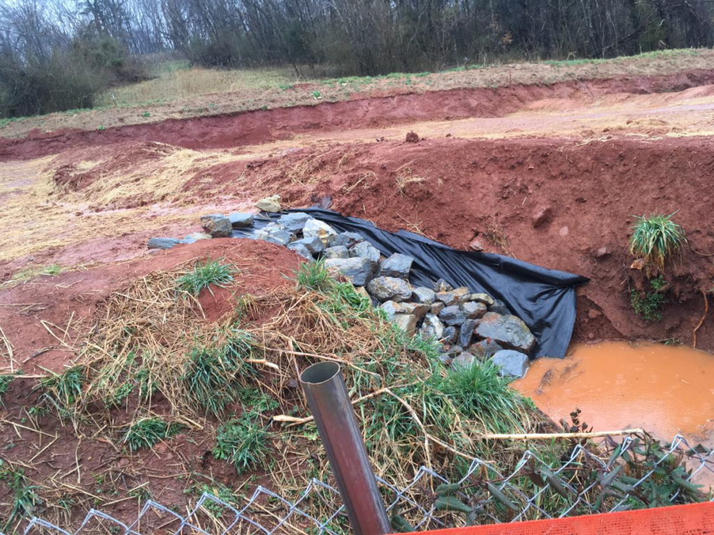
1. The construction plans as designed are not adequate. The erosion control devices selected for use do not have the capacity to prevent erosion from flowing offsite. Sediment trapping devices were not included in the plan. See photo below for illustration of inadequate plan design. The plans should have included a sediment trap at the toe of slope to contain sediment onsite. Instead, the plans show silt fence at the toe of the slope. Engineering design criteria for silt fence was not followed when the engineer designed the plan. Sediment flows offsite onto adjacent property despite efforts by the contractor to contain sediment with one straw bale. This is one of numerous examples where the construction plans fail to adequately contain sediment on site. See photo below (Figure 18).

2. Lack of adequate vegetative cover on disturbed areas per Standards and Specifications and Minimum Standards 1 and 2. Despite efforts to seed the construction right of way by the contractor, there are many areas where grass is not growing. Aerial flyovers and observations by individuals have recorded many areas where soil stockpiles are not growing vegetative cover and are eroding into nearby streams and creeks. See soil stockpile photo below.
Many areas have not been actively under construction for several months, yet they are not seeded adequately to grow grass. No areas have been re-seeded to try to get an adequate stand of grass on bare areas.
A Basic premise of erosion control is to disturb as little soil as possible and to quickly build the project in order to minimize environmental impacts. MVP has disturbed large areas of land and left these areas open to the elements exposing them to continuing erosion. MVP has exceeded Minimum Standard 1 repeatedly by not seeding open areas after 14 days of construction inactivity. This is a repeat pattern that deserves the Board’s attention. See soil stockpile photo below (Figure 19) for an example of lack of vegetative cover after prolonged exposure to the elements.

3. Construction of the pipeline began with tree felling in January 2018. Since then, MVP has lost several key permits and experienced ongoing delays. Currently, crews cannot construct across any streams or wetlands that have been designated under Army Corps of Engineers jurisdiction, and cannot construct along 25 miles of the route in Giles and Montgomery Counties due to permits issued by the US Forest Service and Bureau of Land Management subsequently vacated by the Fourth Circuit court. The required comment periods for reissuing these permits could prevent construction in these areas for another three to six months.
With multiple permits still missing, lawsuits still pending, and no clear route for reinstating stream and wetland crossing permits, construction in the Jefferson National Forest and across the Appalachian Trail, this would be an opportune time to re-evaluate the construction plans and issue a Stop Work Notice on the MVP until re-designed plans are proven to be adequate, and there is grass growing on the pipeline right of way in accordance with Standards and Specifications.