PDF of the report.
June Virginia Water Control Board Meeting
We clarify here the relationship of our organization to the Board and DEQ Staff. The State Water Control Board is responsible for administering the Virginia Water Control Law. The Board adopts regulations and has authority to enforce its regulations and permits. It is completely on your shoulders to oversee this project.
The Mountain Valley Watch (MVW) is a citizen volunteer organization organized to observe construction and document erosion control problem areas. Local volunteers report incidents of erosion problems to the MVW and then the incidents are reported to the DEQ by the MVW coordinator.
At the last meeting of the Virginia Water Control Board on June 27, 2019, DEQ staff attempted to avoid responsibility for DEQ’s failure to identify or act on environmental issues related to Mountain Valley Pipeline construction by shifting some of the blame to the Mountain Valley Watch. DEQ is responsible for insuring that inspectors are on the job after every storm event to record and enforce erosion control problems.
The MVW has local volunteers who live near the locations of problem areas. They have the ability to respond quickly. The DEQ could and should utilize Mountain Valley Watch’s input and photographic evidence to confirm and supplement reports from DEQ inspectors. More than 750 incidents of alleged erosion control problems are shown on the MVW Data Dashboard link: MVW Data Dashboard. This information is available to the public and DEQ for review.
Recent Problem Areas
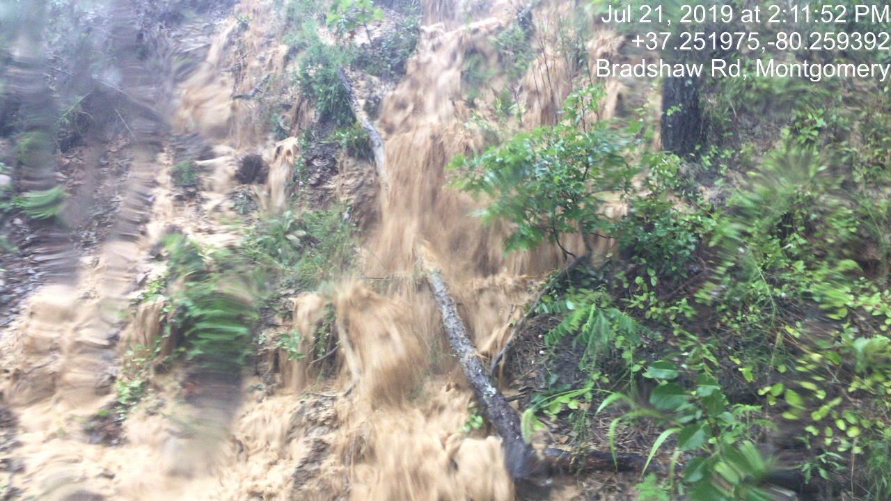
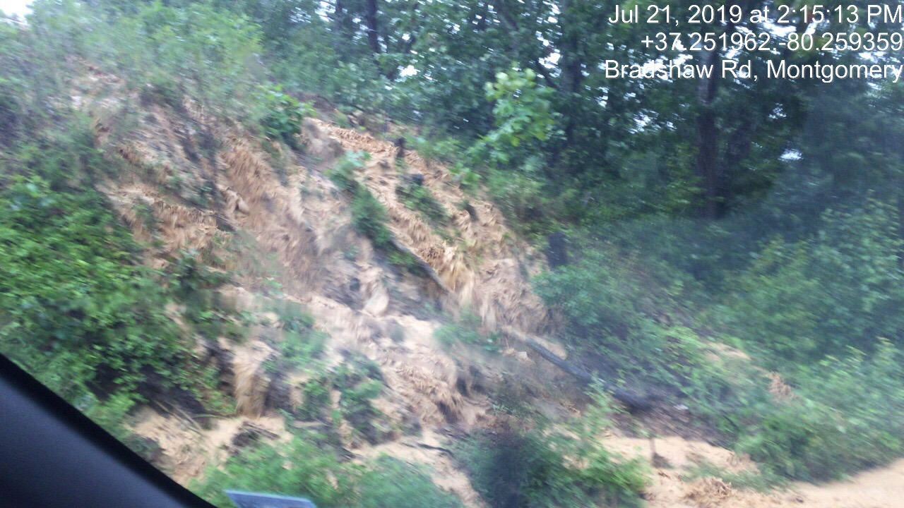
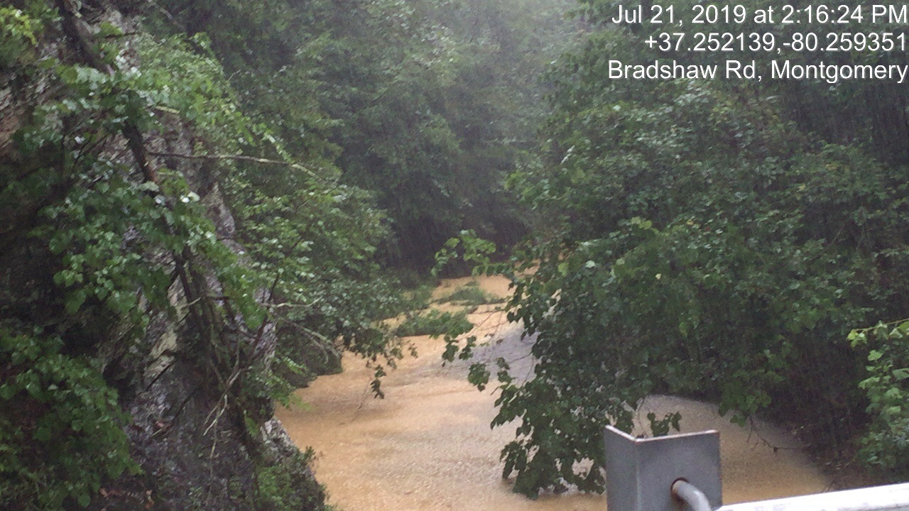
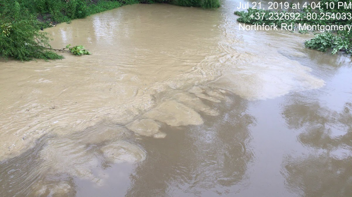
Bradshaw Creek – Montgomery County, VA
In July 2019, rainfall events overwhelmed erosion control devices at the intersection of Bradshaw Creek and Mountain Valley Pipeline’s right-of-way. Sediment laden runoff flowed down steep slopes above Bradshaw Road and into Bradshaw Creek. The photos below are pictorial documentation of the volume of sediment flowing into Bradshaw Creek. Erosion control devices failed to keep sediment laden water onsite. A combination of inadequate erosion control measures and steep slopes compounded the situation.


Green Creek Crossing – Franklin County, VA
A severe sedimentation incident at this site was observed in the field on July 23, 2019 around 10:15 am and reported by Mountain Valley Watch to DEQ’s PReP database on July 23, 2019 at 3:26 pm (reference number 291600), with additional information and photos submitted in a formal report at 3:28 pm. The formal report was sent to DEQ’s automated email associated with the PReP database, as well as directly to Jerome Brooks and John McCutcheon.

As of September 3, 2019, no complaint investigation report is publically available on the DEQ website for this incident. The only reference to alleged inspections of the site are in the following quoted material from the PReP database:
Status Reason: Appropriate compliance actions completed and verified by DEQ, Closure Comment: DEQ/MBP inspectors returned to the area on 8/3/19 and observed the specified repairs to the timber bridge geotextile liner had been completed. Sediment that had been deposited in the stream was reported removed on 7/27/18 [sic] and on the 8/3/19 inspection, DEQ/MBP inspectors verified that sediment in the stream bed had been retrieved.
Sedimentation in the Roanoke River
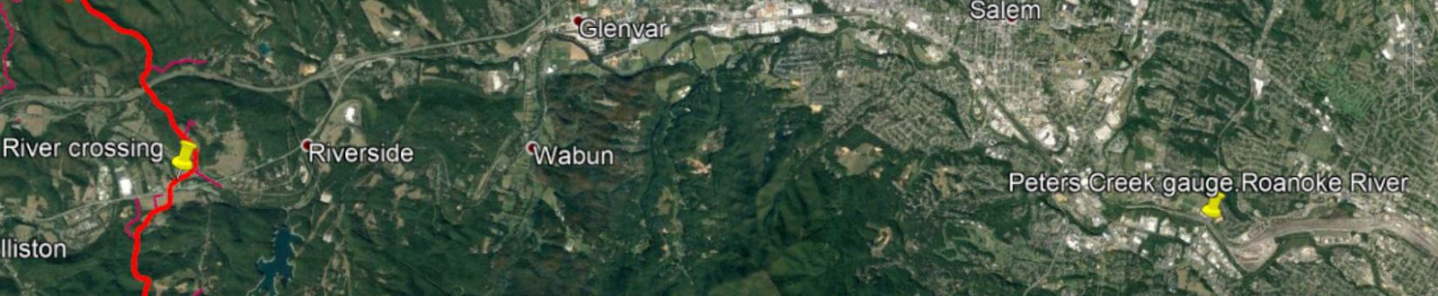
There are 3 USGS water monitoring gauges on the upper Roanoke River, all on the main stem. Two are located immediately upstream and downstream of the proposed open cut crossing of the Roanoke River by Mountain Valley Pipeline. The third is at the Peters Creek Road bridge where the Roanoke River enters the City of Roanoke.
See map below with approximate gauge locations marked with two yellow pins. RED = MVP ROW.
All three gauges on the Roanoke River experienced very high levels of turbidity through Salem and Roanoke following rainfall in the North Fork Roanoke River watershed and its tributaries (including Bradshaw Creek) on the evening of July 15, 2019. These readings are unprecedented for these gauges, even during the exceptionally high rainfall during 2018.
What changed between 2018 and 2019?
Mountain Valley Pipeline cleared and graded many miles of steep slopes above dozens of waterways that are tributaries of the Roanoke River.
Turbidity measurements for the Roanoke River are shown on the graph below in formazin nephelometric units (FNU). According to USGS documentation, readings >1,000 FNU are considered “very high.”

Why did turbidity rise? It appears likely that a localized storm on the North Fork of the Roanoke River and its tributary, Bradshaw Creek, along the MVP right-of-way (ROW) was a major contributor to the problem.
Additional problems occurred and were reported when it rained during the week of July 21, and all three gauges showed a second, smaller spike and ongoing impairment that would impact the endangered species Roanoke Logperch. Note that even though there was less rainfall than on July 15, the river sustained a higher than normal level of turbidity for days. This indicates that the soils in this area have a high clay content with small soil particles that remain suspended in water for long periods of time. The endangered Roanoke logperch and other aquatic life are directly impacted by days of muddy water.
This evidence clearly shows that MVP has failed to keep the disturbed sediment from its construction activities within the designated limits of disturbance (LOD) as required and increased sediment loads are entering the North Fork of the Roanoke River. High turbidity is a species-threatening impact on three “natural heritage resources of concern” that reside in the North Fork and its tributaries as well as main stem of Roanoke River. The Commonwealth of Virginia Department of Conservation and Natural Resources stated in its November 30, 2017 environmental impact review of MVP their concerns about three species: Roanoke logperch (Percina rex), Orangefin madtom (Noturus gilberti) and Spatulate snowfly (Allocapnia simmonsi). Qualified experts have repeatedly questioned whether the MVP could prevent species threatening sedimentation in the Roanoke River and its tributaries.
Recurrent Problem Areas
Angle Farm – Franklin County, VA
The Angle Farm has seen recurrent issues since construction began on the Mountain Valley Pipeline. Below is a set of images showing a breached silt fence on October 14, 2018. Moving ahead to July 2019 observations show the same hole, in the same silt fence, in the same location, continuing to fail and provide an increased sediment loads to the Blackwater River.


Wades Gap Road – Franklin County, VA
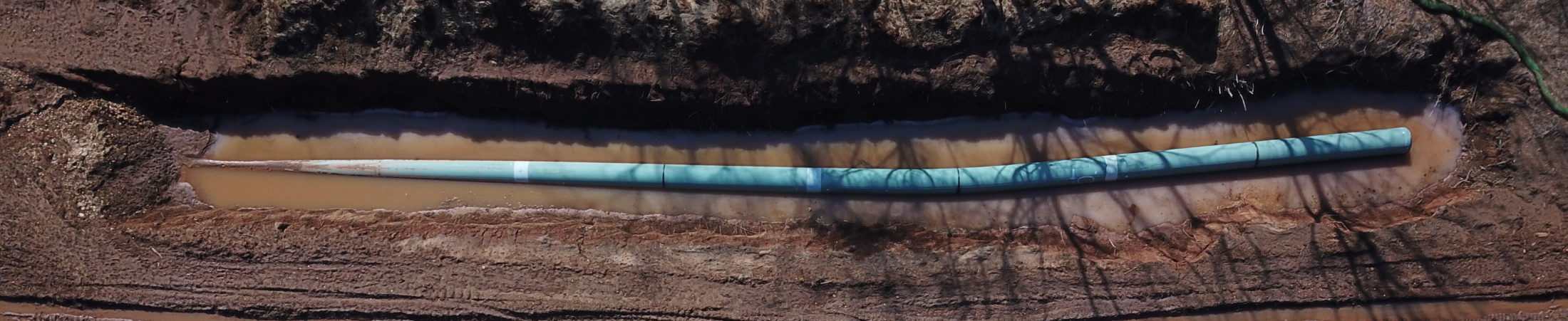
Wades Gap Road in Franklin County, VA is one of the sites where MVP requested and gained approval from FERC (via Variance Request MVP-014) to cross the stream via conventional bore rather than the dry-cut open trench method originally approved in the FERC Final Environmental Impact Statement. At varying times throughout the last several weeks, volunteers have observed muddy water, as well as clear water in this bore pit, following days of little to no rain. It appears to be the community’s groundwater rising in the trench, and MVP seems to have been pumping water continuously out of this bore pit. The conditions at this site spur ongoing concerns about groundwater impacts from expected and unexpected construction activities.

Division of Geology & Mineral Resources Landslide Report
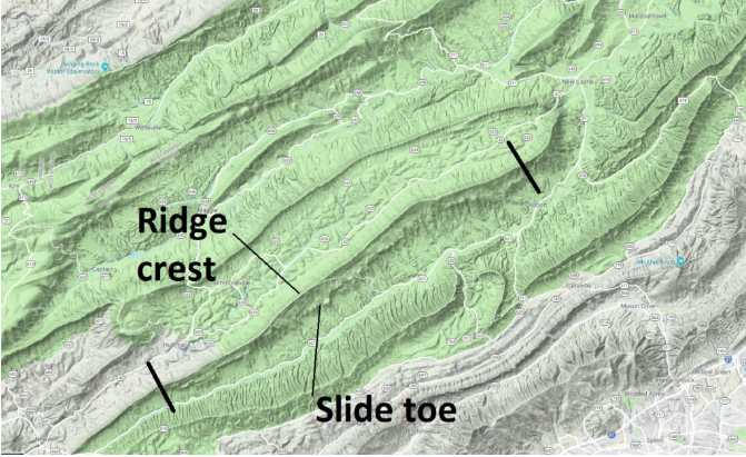
Philip S. Prince, with the Virginia Division of Geology and Mineral Resources, recently published an article titled “The landslide that is too big to notice.”1 The figure below shows the location of the landslide study on Sinking Creek mountain in Montgomery County, VA. The western most black line is the MVP crossing at Sinking Creek Mountain. It is imperative that geologic field surveys are conducted to explore slope stability at the ridge and down the southeast slope of Sinking Creek Mountain (Montgomery County side) to ensure slope is stable enough to construct and restore without triggering a landslide.
There are currently springs (more than one) that traverse across the MVP ROW on this slope. After a storm, Sinking Creek Mountain has some very impressive hydraulic pressure impacting that environment. A long linear infrastructure project, like MVP, has the potential to block underground water from flowing to springs, causing increased hydraulic pressure on the natural spring path and potential failure of the slope along the same slip surface formation. This is a note of concern regarding this location and should be further evaluated with an extensive geologic field study and slope stability analysis.
Conclusions and Revocation Request
In light of the recent endangered species decision for the Atlantic Coast Pipeline from the Fourth Circuit court and direction from the Federal Energy Regulatory Commission to re-initiate consultation on the Biological Opinion and Incidental Take Statement for the MVP, this is another opportunity for the Water Control Board to step up and halt a project that has demonstrated time after time that erosion and sediment control measures are not adequate to protect Virginia’s streams and rivers. We request reconsideration and revocation of the Section 401 Certification for the Mountain Valley Pipeline. Considerable damage has occurred to streams and rivers which has jeopardized the Roanoke Logperch and other aquatic endangered species. A recent Stop Work Order from DEQ further demonstrates the lack of adequate erosion control measures. The Lawsuit filed by Attorney General Herring in December 2018 is still unresolved. In light of these issues, immediate action is required to prevent further damage to streams and impacts to endangered species.
In addition, another issue is that the MVP will have devastating climate impacts. We are living in climate change and a project of this magnitude will contribute emissions (fracking, leakage during transport, burning) that add an additional 54 to 91 million tons of GHG per year to the atmosphere, according to a Sierra Club report. Currently, the Commonwealth of Virginia is responsible for 49.7 million tons of greenhouse gasses (GHG) per year. In other words, this single unneeded and dangerous transmission pipeline will at least double and potentially almost triple the Commonwealth’s GHG contributions.2
In a recent Roanoke Times article the CEO of Midstream Partners, the lead company in the joint venture, was quoted:
“I don’t want to lose sight of the fact that this is a 50- to 80-year investment that’s going to be incredibly valuable to this company,” Thomas Karam said in an April teleconference to discuss first quarter results with financial analysts. “With each month that we construct it, we take more budget risks and timing risks off the table.”3
The climate crisis, that includes extinction for some species, will be a far longer cleanup than the 50-80 year investment for this company. Changing weather patterns are leading to more extreme weather events and seasons. The climate impacts on Virginia will be far reaching as we double our greenhouse gas contributions. Virginia has military installations in areas that will be underwater with a 20 foot sea level rise. The following link is to a map showing U.S. land less than 20 feet, or 6 meters, above the high tide line. That is the minimum amount of eventual sea level rise projected from 2 degrees Celsius (3.6°F) of global warming, according to a comprehensive review published in the journal Science.4
Footnotes
1Prince, Philip S, Virginia Division of Geology and Mineral Resources, April 28, 2019, https://geomodelsvt.wordpress.com/2019/04/28/sinking-creek-mountain-and-the-landslide-that-is-too-big-to-notice/
2Climate Disrupting Pollution from Atlantic Coast and Mountain Valley Pipelines nearly twice that of Virginia power plants and other stationary sources, Richard Ball, PhD, Sierra Club, https://www.sierraclub.org/sites/www.sierraclub.org/files/sce/virginia-chapter/documents/Release%20Carbon%20Pollution%20from%20Pipelines-FINAL.pdf
3Laurence Hammack. “Stop-work order does not go far enough, pipeline opponents say.” Roanoke Times, August 6, 2019.
4Surging Seas 2oC Warming and Sea Level Rise, NSF funded, https://ss6m.climatecentral.org/#9/36.8181/-75.7507