This report was revised before being posted July 5, 2019
PDF of the report.
Introduction
This report is the most recent in a series of reports that the Mountain Valley Watch (MVW) has prepared to document erosion problems associated with construction of the Mountain Valley Pipeline. Since April 2018, citizens and local residents reported more than 610 incidents of alleged erosion control problems and violations to the MVW. A number of these problem areas were reported to the Department of Environmental Quality for follow up with site visits by inspectors.
See the Mountain Valley Watch mapping link: Incident reports mapping
Several areas in Montgomery, Roanoke and Franklin counties are recurrent problems with erosion control issues that prove difficult to resolve.There are numerous areas in the construction right-of-way that have lain bare of vegetation for many months in violation of Minimum Standards One and Two. This report documents several areas with recurrent issues and areas with lack of vegetation.
Recurrent Issues
Grassy Hill Road
Grassy Hill Road in Franklin County Virginia is a site with recurrent sedimentation issues during each rain event. Sediment flowing from the riprap area is visible in the top photo along Teels Creek and the convergence with a clear stream just downstream from the sediment plume is shown in the lower photo.
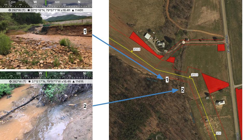
Directly below convergence of Teels Creek, the stream bank has shifted due to channel erosion created by increased runoff from the MVP right of way. Scouring of the stream bank has moved the bank several feet from its original location before construction began for the MVP. The bank continues to erode as illustrated in the photos below.

Brush Mountain & Mount Tabor Road
Erosion & Sediment control devices are continually overwhelmed by normal precipitation events in areas of Brush Mountain and Mount Tabor Road in Montgomery County. There are recurrent issues as illustrated in the pictures below taken on May 5, 2019. The devices used in this area are not adequate to control runoff from the construction right of way. As seen in the photos, runoff exceeds the capacity of filter socks to contain sediment on site. Sediment flows around or over filter socks and flows into adjacent stream. See photos below.

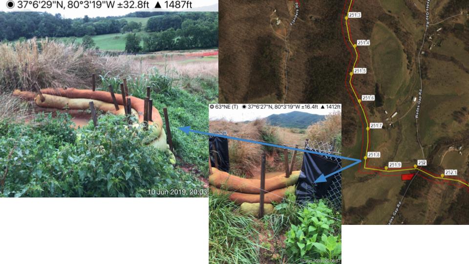
Wades Gap Road
Angle Farm
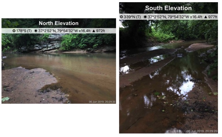
Dean and Dale Angle’s farms are adjacent to Little Creek and the Blackwater River and have been heavily impacted by unsecured earth loss. The Angle farms have suffered severe sediment impacts since May 2018. The farm is below MVP construction sites on Little Creek at Cahas Mountain Road and below the convergence of Teel Creek, all heavily impacted by construction. Sediment flowing from the watershed above their farms combines with sediment from their property to silt in the waterways shown in the photos below .
Bare Soil
A number of areas are still denuded and not growing grass after months of attempts to stabilize slopes. Figures 6, 7 and 8 show locations on the Angle farm. Figure 9 shows bare soil on the Buford property, followed by locations near Foggy Ridge Road, Cahas Mountain Road, and Route 221 in Franklin County, VA.
Examination of aerial images, from a flyover on 4/21/2019, shows ~35 miles of ROW length not stabilized with vegetation or straw. County breakdown is as follows:
Franklin – 18.2 miles
Montgomery – 0.19 miles
Pittsylvania – 16.7 miles
This is equivalent to ~700 acres of ROW.
The area below in Franklin County has large areas that are bare of vegetation since last Fall 2018. Silt fence below the soil stockpile is in need of maintenance to prevent sediment from flowing off site.


Helicopter Flyovers/Seeding
As noted in our April 2019 report, MVP is continuing to use low-flying helicopters to seed the ROW haphazardly with erosion control pellets. These pellets contain anionic polyacrylamide (PAM) and were spotted in waterways off the ROW in several areas.
In DEQ’s Erosion & Sediment Control Technical Bulletin #2, Application of anionic polyacrylamide (PAM) for soil stabilization and stormwater management, PAM may only be applied in accordance with an approved plan/permit and on areas that ultimately drain to a pre-constructed sediment trap or basin prior to introduction to surface waters. Application of PAM does not meet the requirements stated in Bulletin #2 because there are no sediment basins or traps in the construction right-of-way. Another requirement of Bulletin #2 is that users must obtain site-specific soil and water testing and guidance from a qualified manufacturer to ensure that an (a) Anionic PAM product, (b) additives, and (c) application scheme are selected that is tailored to site-specific soil characteristics.
Temporary seeding by helicopter has not germinated in many areas. The soil has lain bare for months at a time and is hard packed due to exposure to the sun. The soil bed was not prepared for seeding per seeding requirements specified in the Virginia Erosion and Sediment Control Handbook. There are clay soils in Franklin County that are difficult to seed without adequate seedbed preparation.
The photo below shows an area that has remained bare for over six months.

Green Hollow Drive
Bent Mountain’s historic Green Hollow Drive is experiencing flooding on a regular basis during typical rainfall events. This is caused by a blocked culvert. Sediment flowing from the MVP constriction on sites at the Blue Ridge Parkway and the US 221 crossing carry sediment in the Mill Creek Watershed to this site.The sediment has accumulated at the culvert inlet — which is within the LOD of Green Hollow Drive as an access road — blocking flow and flooding areas upstream of culvert. The existing road is often underwater due to flooding. The timber mat bridge and silt fence are acting as a dam rather than controlling erosion or sedimentation on Green Hollow Drive. It is the responsibility of the contractor to remove debris and sediment clogging the culvert, which has not been done. MVP was made aware of flooding and sediment off the LOD at Green Hollow Drive in 2018.

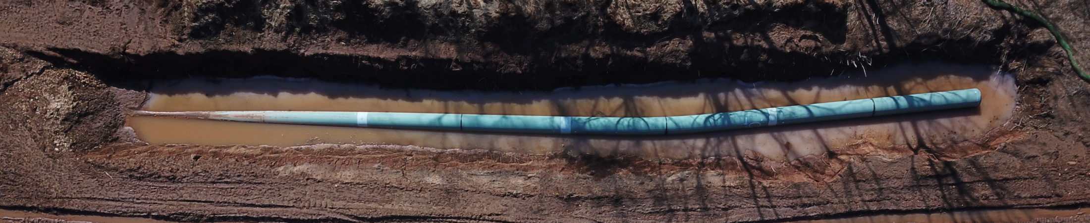
Variances for boring under waters of the USA
On June 11, 2019, Mountain Valley Pipeline requested a variance from FERC to change their method of crossing 12 streams and one wetland across Virginia and West Virginia, marked as Variance Request MVP-014. This request — approved June 14 — included three crossings in Franklin County, VA. FERC approved the variance because MVP attached correspondence from the U.S. Army Corps of Engineers to FERC Project Manager Paul Friedman:
Paul,
As you requested today, below is a response to your question about horizontal directional drill (HDD) (or directional bore) under small non‐Navigable streams (and Non‐Section 10 designated slack waters), which ARE NOT regulated pursuant to Section 10 of the Rivers and Harbors Act, but ARE REGULATED by this office pursuant to Section 404 of the Clean Water Act:
*An HDD constructed entirely under these types of jurisdictional waters can be performed in a manner that would not constitute a discharge of dredged or fill material.
Neither MVP nor FERC gave any indication that state agencies had been consulted in any way associated with the approval of this request. While DEQ and the Board relied on the Army Corps Nationwide 12 Permit to regulate stream and wetland crossings in Virginia, they did certify upland impacts under their Clean Water Act Section 401 certification. If the change in construction technique does not fall under Corps jurisdiction, then it would presumably fall under the jurisdiction of DEQ and the Board.
An objection was filed with FERC to the variance approval on the following grounds:
1) This is a significant engineering and scientific departure from the details of the FEIS, the Certificate as approved by the Commission and those crossings considered for underground boring in the considerations of the Virginia Marine Resources Commission; it is further not clear whether additional surveys for fragile species are required for underground boring in these areas;
2) The Virginia Department of Environmental Quality, and other environmental agencies, have not been publicly consulted; neither has the State Water Control Board responsible for protecting water quality been consulted;
3) The public, including independent scientists knowledgeable of soils and bedrock formations at these sites have virtually no opportunity to review construction plans and comment; moreover construction plans as filed provide scant engineering design information;
4) It is not clear that boring is appropriate to these sites or whether boring is being used as an end run around the Fourth Circuit’s vacatur of the Army Corps permit, which is still vacated;
5) There is significant evidence at sites in Virginia that the request to bore was not a request at all, but rather a “formality.” Photographs indicate significant earth moving equipment, including two bore drills have been moved to each of three sites in the days and weeks prior to FERC agents plan to grant the variance;
6) We ask that the FERC Commission, in order to begin Chair Chatterjee’s recent statements of intent to consider the rights of landowners and stakeholder communities, deny the request for Variance or, in the alternative, to pause for allowance for public review and comment.
When the Board approved their certification of the Mountain Valley Pipeline in December 2017, the last paragraph states that “the Commonwealth reserves its right to review this certification decision and take any appropriate action in accordance with 33 U.S.C. § 1341(a)(3),” which includes a provision for reconsideration “because of changes since the construction license or permit certification was issued in (A) the construction or operation of the facility.”
In light of the fact that neither the Board nor the Virginia DEQ were publicly consulted on Variance Request MVP-014, we urge the Board to exercise their authority to suspend the Erosion and Sediment Control plans for the Mountain Valley Pipeline pending reconsideration given the new information and construction techniques included in Variance Request MVP-014.
Additionally, we urge the Board to issue Notices to Comply in the areas noted above where we have documented and reported bare soils and repeated violations of Erosion and Sediment Control Regulations.
The Time to Act is immediate before construction begins through the most complex geologic conditions in Virginia. The perched aquifer on Bent Mountain, karst terrain in Craig, Montgomery and Giles County, and the steep slopes of the Appalachian mountains and Blue Ridge will present construction challenges. We fear that the consequences of construction will result in additional sediment loads into streams and rivers along the MVP.
We reiterate that the Water Control Board has legal authority to stop work on the Mountain Valley Pipeline. Please consider a resolution directed to DEQ asking for issuance of Notices to Comply for recurrent problem areas and bare soil areas. These areas are not in compliance with erosion control regulations. The State Water Control Board is responsible for administering Virginia Water Control Law. The board can adopt regulations and consider special orders resolving violations of its regulations and permits.
We maintain that the Laws have been violated and enforcement efforts are weak. As authorized under the Law, it is the Board’s responsibility to make sure the erosion control laws are enforced. We have reported and documented numerous violations, yet adequate enforcement has not been applied. Again, we request stringent construction inspection and enforcement of erosion control laws by DEQ. Inspection work performed by DEQ has not been adequate to control construction runoff resulting from the Mountain Valley Pipeline.